Friday, 05:50UTC
The storm is becoming more and more intense in Berlin
Friday, 05:30UTC
The storm is now battering Berlin. The wind howls over roofs, seems to want to press the windows into the buildings. It is horrific, but also terrific. The sounds are amazing.
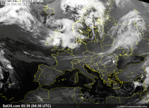
But behind the actual low pressure area is even more storm, and that storm is what Germany is currently experiencing.
Thursday, 18:05UTC
More fotos of the current storm…
All images come from wetteronline dot de

The weather network on Twitter

Gerrit van den Geest over Twitter

John Rhodes over twitter

MunnsMedia over Twitter
Thursday, 17:10UTC
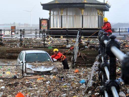
Some images of the storm and it’s effects. All images come from www.wetteronline.de
More images coming soon

www.wetteronline.de

Expresselbe on Twitter

Mariane Luinstra on Twitter
Thursday, 17:02UTC
The storm has reached Berlin. A desaster warning hs been issued by the government of Berlin. The storm is currently very intense, dumping huge amounts of snow, which started recently. Schools are publishing their own restrictions that students are not allowed to leave the school buildings.
Thursday, 10:45UTC
The center of Xaver is currentl located E of GB.
The currently strongest gusts in Germany are reported from the Brocken, with 119kmh. Berlin is currently still calm.
Thursday, 08:30UTC
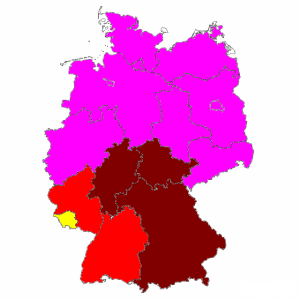
Update: the current situation in Germany. The weather service(s) DWD and Meteomedia have now published warnings that are not considered pre-warnings, but rather disaster warnings.
The storm Xaver is currently E of the British islands and moving towards the Baltic relatively quickly. Berlin and Kleinmachnow, where we are reporting from, are not yet affected by the wind field, although the cloud cover has increased within the last hours and thre pressure has fallen. First rain areas/fields are already being reported in NW Germany. We will keep you updated.
Thursday, 06:30UTC
The cloud field has now reached the NW coast of Germany. The serious stuff is beginning.
Thursday, 04:58UTC
Just now a report reached us: The peak gusts in GB were in fact quite a bit higher than expected;163kmh in the highlands.
Thursday, 04:55UTC
Coming with the storm is a cold front, which is causing thunderstorms along its leangth. See the map below for live information about the thunderstorms’ positions.

Updates automatically
Thursday, 04:50UTC
We are now reporting on the day the storm acutaly strikes Germany. The cloudy area that was in the middle of the Atlantic still yesterday now is a full fledged storm and also lookes like it. RIght now, consistant winds of 117kmh are battering two islands NW of the main island of GB, even though the storm doesn’t even strike directly there.
—————————————-THURSDAY————————
Wednesday, 05:30UTC
Warnings for tomorrow:
Wednesday, 05:05UTC:
Here come the warnings for specific cities
Hamburg: 90 to 120, sometimes 130kmh on Thursday, 80 to 100kmh on Friday
Kiel: 110 to 140kmh, sometimes over 150kmh on Thursday, 80 to 110kmh on Friday.
Helgoland: 130 to 170kmh, sometimes 190kmh on Thursday, 100 to 140kmh on Friday.
Rotock: 80 to 120kmh, sometimes 130kmh, 80 to 100kmh on Friday
Bremen: 90 to 120kmh, sometimes 130kmh on Thursday, 80 to 100kmh on Friday
Hannover: 90 to 120kmh, sometimes 130kmh on Thursday, 8o to 100kmh on Friday
Potsdam: 90 to 12o, sometimes 130kmh on Thursday, 80 to 100kmh on Friday.
Berlin: 90 to 120kmh, sometimes 130kmh on Thursday, 80 to 100kmh on Friday.
Köln: 90 to 100kmh, sometimes 110kmh on Thursday, 80 to 90kmh on Friday.
Leipzig: 90 to 120kmh, sometimes 130km on Thursday, 80 to 100kmh on Friday
Same for most of the other cities.
Wednesday, 05:00UTC
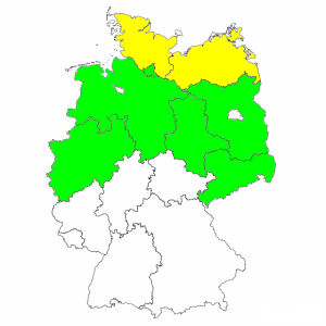
Green: strong wind
Yellow: Severe wind
—————————- WEDNESDAY IS ABOVE ————————————
Tuesday, 05:20UTC
The storm will bring a drop of temperatures as well. See the lowest temperatures expected for Germany that follow: (mountains NOT included)
- Today: -4°C
- Tomorrow: -3°C
- Thursday: -5°C
- Friday: -5°C
- Saturday: -10°c
- Sunday: -12°C
- Monday: -12°C
- Tuesday: -18°C
Tuesday, 05:15UTC
But what about the snow exactly?
It will begin to snow locally and for a short time in front of the front with extreme rain that will move in very rapidly. As the air cools down in the evening, more and more of the rain will turn to snow, especially around the edge of the rain area. In the night most of the rain will turn to snow, already in the late evening it will snow in Berlin and Bremen, and strong snow showers will move through Hamburg. The snow showers are particularily dangerous, since they will dump great ammounts of snow in very local regions very quickly, and are likely to cause a great chaos. It will continue to snow in the night, and during the night the very rare snow thunderstorms are expected in the north sea and on the island Helgoland. During the early morning hours there will be some more snow thunderstorms, mainly in the region of the north sea. But also freezing rain will become a possible problem in E Germany. The strong snow showers will continue, and even if it snows without showery characteristics it is likely that it will still snow hard. From the storm on, most of the precipitation will be frozen.
Tuesday, 05UTC
As far as forecast until now, the Storm will strike central Europe the hardest, bringing gusts over 155kmh to Denmark and far N Germany. Also Germany’s capital, Berlin, is expected to get struck by gusts that may exceed 100kmh.
As of Germany, the storm will move in Thursday, with intense rain and only some snow flakes before the incredibly intense rain beginns. Over the night the atmosphere will cool down, and the rain will turn to snow. Also the rain that already fell will turn to ice. This will mean a big chaos in transportation.
Please see the earlier post with the early warning map
————————- TUESDAY ———————————————


