Today is the last day of the regular ESC overviews, as the European (wind-)storm season comes to an end. ESC will, however, still issue overview, warnings and watches in dangerous situations throughout the rest of the year. Below is today’s ESC overview. Live data can be fount at www.milk-weather.org
2016.02.24 – ESC Overview: No risk for Europe
2016.02.22 – ESC Overview: No warnings
2016.02.21 – ESC Overview/Warnings/Watches: Not much change
Storm XIN remains the only storm affecting Europe. Thanks to this system, a strong westerly flow of air is affecting mainland Europe, bringing storm gusts. Other than the regions affected by this western air flow, Iceland and the islands in the North Sea will also be affected by storm gusts, caused directly by storm XIN.
2016.02.20 – ESC Overview/Warnings/Watches: Storm XIN in Europe
2016.02.19 – EUROPE: Weather for the Weekend
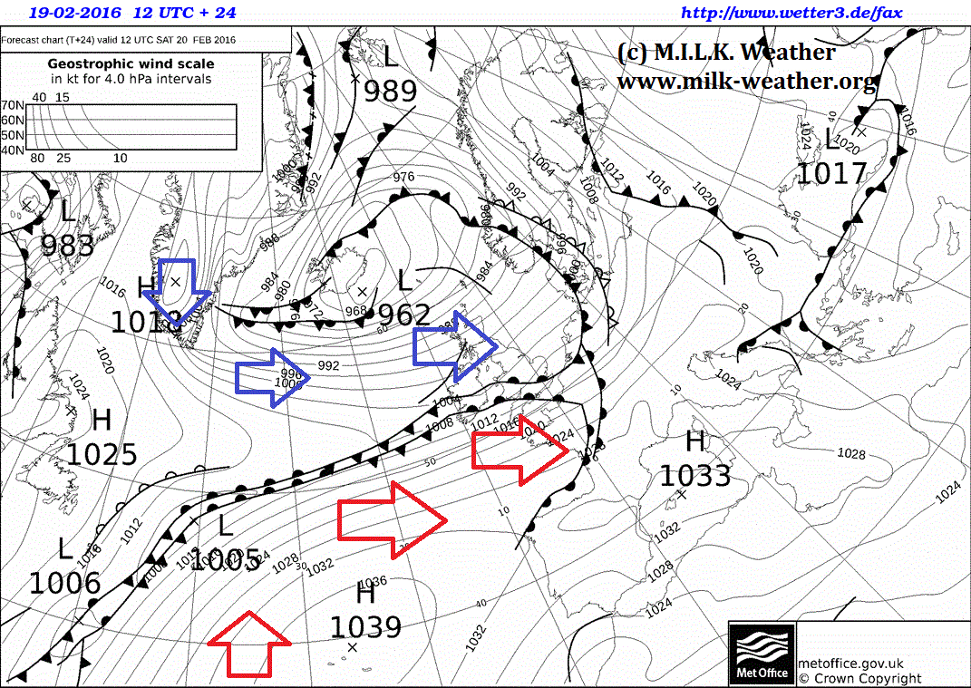
On Saturday, the frontal system of Storm XIN (See the M.I.L.K. European Storm Center) will advance further to the east. Following behind is a cold and windy maritime-polar air mass flowing from Greenland over the UK and into Scandinavia. However, the polar front will be well defined tomorrow and will also stretch quite far to the east. The front will seperate the cool, arctic air mass in the north from a much milder, yet still humid air mass to the south. The edited UK Met. Office ground prediction map for tomorrow, 12UTC shows the way the air masses travel.
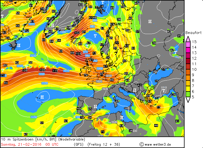
Along the polar front and around storm XIN, storm gusts are to be expected, and regionally, damaging winds are possible. Wind speeds are expected to reach their maximum along the coasts of the North Sea and especially in the north of the UK in the night from Saturday to Sunday. Below is a current GFS forecast map for the peak gusts at 00UTC in the night from Saturday to Sunday.
Once again, the M.I.L.K. ESC (European Storm Center) will keep you updated.
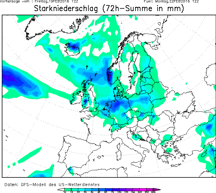
With the advance of the warmer air mass into Europe and especially along the polar front, quite significant amounts of rain (in the mountains snow) can accumulate, and there is a risk of local flooding. Current forecasts for Saturday predict the greatest amounts of rain to fall along the north of the Alps and in the Netherlands. In southwestern Norway, quite a bit of snow is expected to fall.
Over night, the warm air mass over mainland Europe will continue to advance eastward, bringing partly heavy rainfall (and possibly storm gusts) at the leading edge.
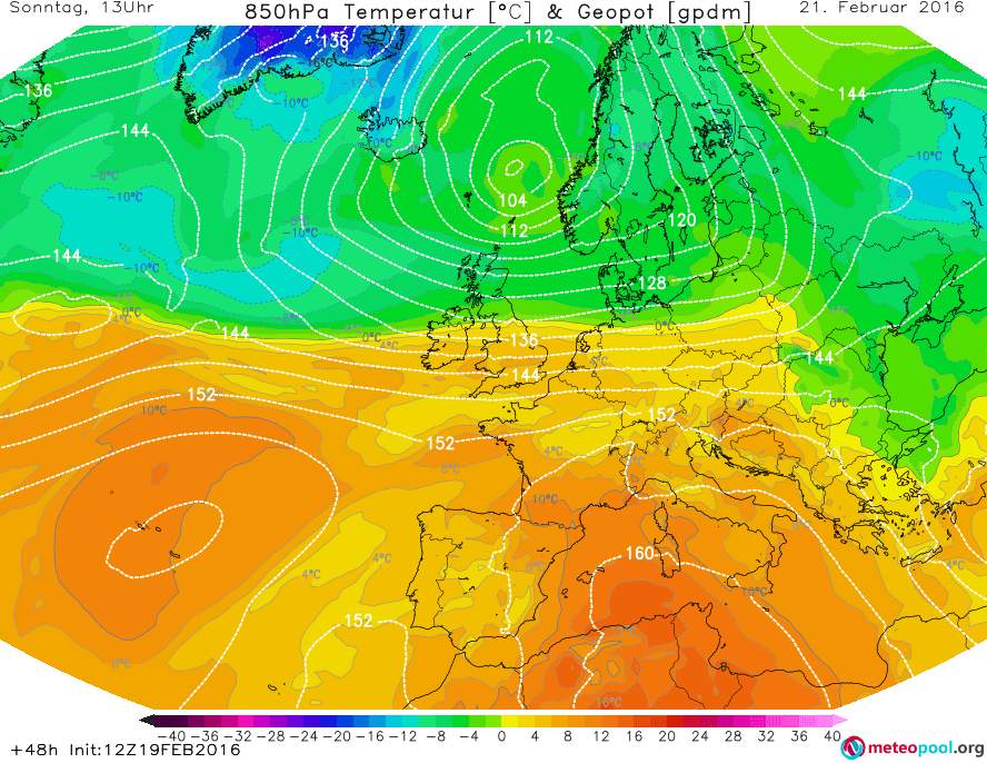
On Sunday, the overall weather situation in Europe will be calmer, because the change in the weather pattern will be more or less complete. Strong rain will, however, continue to fall especiall in the Netherland and northern Germany, and strong precipitation will also continue in southwestern Norway. The Mediterranean will be dominated by friendly high-pressure weather, and the low-pressure system that will dominate in Greece on Saturday and bring showers will have moved on to Turkey. There will be a clear division between the mild air mass over mainland Europe and the cold polar-maritime air mass further north over Scandinavia and the North Sea. This division can be clearly seen in the GFS prediction for temperatures at 850hPa level for Sunday, 12UTC.
Over the course of the afternoon, an advance towards the south of the cool air mass will begin over the British Isles.
In total, there might be some quite significant amounts of precepitation in some parts of Europe, especially southwestern Norway and Northern Germany. Below is the predicted amount of precipitation until Monday, 12UTC.
2016.02.19 – ESC Overview/Warnings/Watches: A change in the weather pattern
A change in the European weather pattern is predicted to take place in the coming 24 hours, which will bring mild and rainy, but also stormy air masses to mainland Europe. Currently, only storm XIN is tracked on the ESC Overview map, and storm warnings have been issued for the UK, Denmark and Norway, as well as a severe storm watch for Iceland due to uncertainties about where, when and how strong the island will be struck. Upcoming is a new low pressure area which is forecast to form over the northern Atlantic today, and is expected to bring storm to mainland Europe – watches have been issued.
Forecaster: LH
2016.02.18 – ESC Overview/Warnings/Watches: Storm XIN
Storm XIN, currently located over southern Greenland, is predicted to continue to move eastward. Iceland is in the path of the storm, and especially the coasts might be affected by storm gusts over 120km/h within 24h. However, due to uncertainties about where, when and how strong Iceland will be affected, ESC has decided to issue a severe storm watch rather than a warning. Later, Mainland Europe and the British Isles might also be affected by storm gusts over 70km/h – watches have been issued.
2016.02.17 – ESC Overview: No storm warnings
The currently only storm system in Europe, located north of Iceland, is currently still fairly powerful, however is expected to dissipate within 24h. There is no risk for major areas on land, some small islands in the north sea and around Iceland might still experience storm-forced wind. Because there is no major landmass affected. ESC has not issued warnings or watches. Below is the latest GFS analysis of peak gusts.
2016.02.15 – ESC Overview: Mainland Europe mainly calm
The ESC Overview as well as watches and warnings have been issued once again! This time, not much wind is to be expected for mainland Europe, but there will be quite a bit of wind on the Islands of the Atlantic. See the Warnings and Watches for more information.
The storm currently just south of Greenland will lose intensity, and the second storm will move to the northeast and quite quickly gain intensity, and will cause severe storm gusts in Ireland, UK, Iceland and the other islands.