
Good morning everyone! And so another day begins – the ESC European Windstorm Overview and warnings will be issued shortly, as will other forecasts, so stay tuned.
Here are two photos of the sunrise in Berlin this morning.


Good morning everyone! And so another day begins – the ESC European Windstorm Overview and warnings will be issued shortly, as will other forecasts, so stay tuned.
Here are two photos of the sunrise in Berlin this morning.
This is the ESC European Windstorm Overview, issued at 0930UTC on the 21.12.2016.
There is currently 1 storm system in the region.
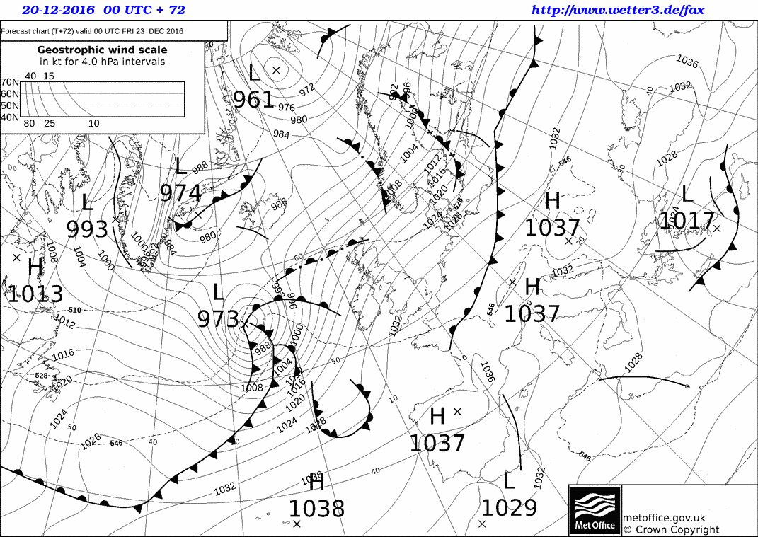
Storm ZARINA is located in the far north of the North Sea, with a central pressure of currently only 942hPa. A peak gust of 166km/h has been registered in Norway. ZARINA is currently battering the west coast of Norway and some North Sea Islands with hurricane-forced winds – ESC has therefore issued a severe storm warning for those regions. The storm is also impacting the rest of the North Sea, Iceland as well as the northern parts of the UK and Ireland; regular storm warnings were issued for these regions. As ZARINA continues to move towards the northeast, wind speeds will pick up in the Baltic within the next 24 hours as well, making a storm warning necessary for some land masses adjacent to the ocean. It is possible that storm gusts occur at the southern coast of Norway and in Denmark towards the end of the 24-hour forecast period, hence a storm watch has been issued for these regions.
Below are the ESC Overview as well as the warnings and watches maps.


Dark red: Severe storm warning (>120km/h likely within 24h)
Red: Storm warning (>70km/h likely within 24h)
Yellow: Storm watch (>70km/h possible within 48h)
Wettervorhersage für BERLIN:
HEUTE bleibt es voraussichtlich den ganzen Tag über sonnig. Es ist allerdings von der Sonnenscheindauer her auch der kürzeste Tag im Jahr, und die Sonne wird schon vor 4 Uhr nachmittags untergehen. Die Temperaturen sind heute Früh mit -3°C recht frostig und bleiben auch Tagsüber mit niedrigen Plusgraden um +2°C recht kühl. Der Wind ist meist leicht und kommt aus Südwesten.
MORGEN Früh gibt es stellenweise Nebel, der zum Teil auch gefrieren kann. Sonst ist es bedeckt oder hochnebelig trüb. Ab dem Nachmittag gegen Sonnenuntergang ist dann mit Regen zu rechnen. Die Temperaturen werden in der Früh wieder etwa 2 Grad unter dem Gefrierpunkt liegen und im Tagesverlauf etwa +3°C erreichen. Der Wind ist leicht und kommt aus Südwesten.
Der FREITAG fängt zwar heiter an, doch schon bald wird der Himmel wieder zuziehen und es bleibt den restlichen Tag lang bedeckt, wenn auch kein Regen erwartet wird. Die Temperaturen dümpeln in den leichten Plusgraden zwischen 0 und 4°C herum und der Wind weht weiterhin leicht aus west bis Südwest.
TREND:
Samstag: Regnerisch, 2 bis 6°C
Sonntag: Regen, 5 bis 11°C
Montag: Wechselhaft, 6 bis 7°C
Dienstag: Wechselhaft, 3 bis 7°C
Mittwoch: Wechselnd bewölkt, 1 bis 2°C
Forecast for DEN HAAG:
TODAY will start off overcast but dry, however in the afternoon rain will start to move in from the ocean. The temperatures will start off slightly above freezing at around 1 or 2 degrees, and are forecast to reach maxima of around 6°C later in the day. The Wind will come from the southwest and will be quite lively – peak gusts up to 60km/h are to be expected.
TOMORROW will start off rainy once again, but soon the clouds are forecast to move away towards the inland and afterwards there may be a few precious hours of sunshine before the sun sets in the afternoon. The temperatures will be between 6 and 8°C, and the wind will be mostly light, coming from the southwest at first, later west.
On FRIDAY it will be overcast all day long, however no rain is expected during the day until the evening. The temperatures will reach from 5 to 8°C. The wind will pick up quite a bit over the course of the day, becoming quite storm by the evening, with storm gusts of up to 90km/h in the evening.
TREND:
Saturday: Cloudy, in the evening rain. 6 to 9°C.
Sunday: Cloudy, 8 to 12°C.
Monday: Fair, 7 to 8°C
Tuesday: Partly cloudy, 6 to 8°C
Wednesday: Partly cloudy, 5 to 8°C
Forecast models suggest that a series of powerful storms will sweep through northern and central Europe around Christmas – here, we will take a closer look at what is expected as of now.
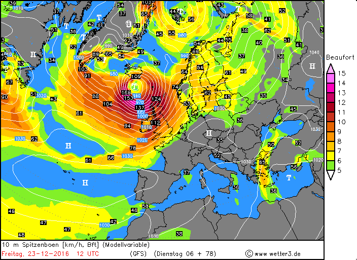
Below is the ground forecast for midnight (UTC) of the 23rd of December. A powerful, well-defined low-pressure system will have formed over the northern Atlantic to the west of the British isles, embedded in a lively westerly flow. Most of the storms in the previous days were located further north, around Iceland, although their storm fields sometimes extended far enough to the south to affect parts of the UK. This new storm, however, will be on a direct path to Ireland and the UK. At this point, gusts in the storm may exceed 165km/h over the open ocean.
The storm will continue to intensify, and by 12UTC its center is predicted to be to the north of Ireland, with the low having deepened to a central pressure of 959hPa. Hurricane-forced storm gusts are to be expected in both the UK and Ireland – in the forecast map below, at 12UTC, the front system with the most intense winds has already passed Ireland and is located over the UK. The highest wind speeds are to be expected in the Scottish highlands and at the coasts of the northern UK.
In the afternoon and evening hours, the center of the low will move towards the northeast, however at the same time the area that the storm field covers will increase. At 18UTC, the most severe parts of the storm field will be located to the north of the British Isles (although it is possible that very intense hurricane-forced gusts over 140km/h affect the far north of the UK), and over the North Sea, where the system of fronts will be located. Large waves and high winds are to be expected at the coasts of Norway as well. In the evening, the fronts will be located off the North Sea coasts of the Netherlands, Germany and Belgium – along the coasts, gusts of around 100km/h are currently forecast, but except for Denmark, the storm field is not expected to move inland.
The storm will continue to rage especially in the northern half of the UK for the hours afterwards, and it will also be stormy in the Baltic and at some of its coasts. By the evening of the 24th, the storm will have weakened with its highest wind speeds in the North Sea and along the coast of Norway.
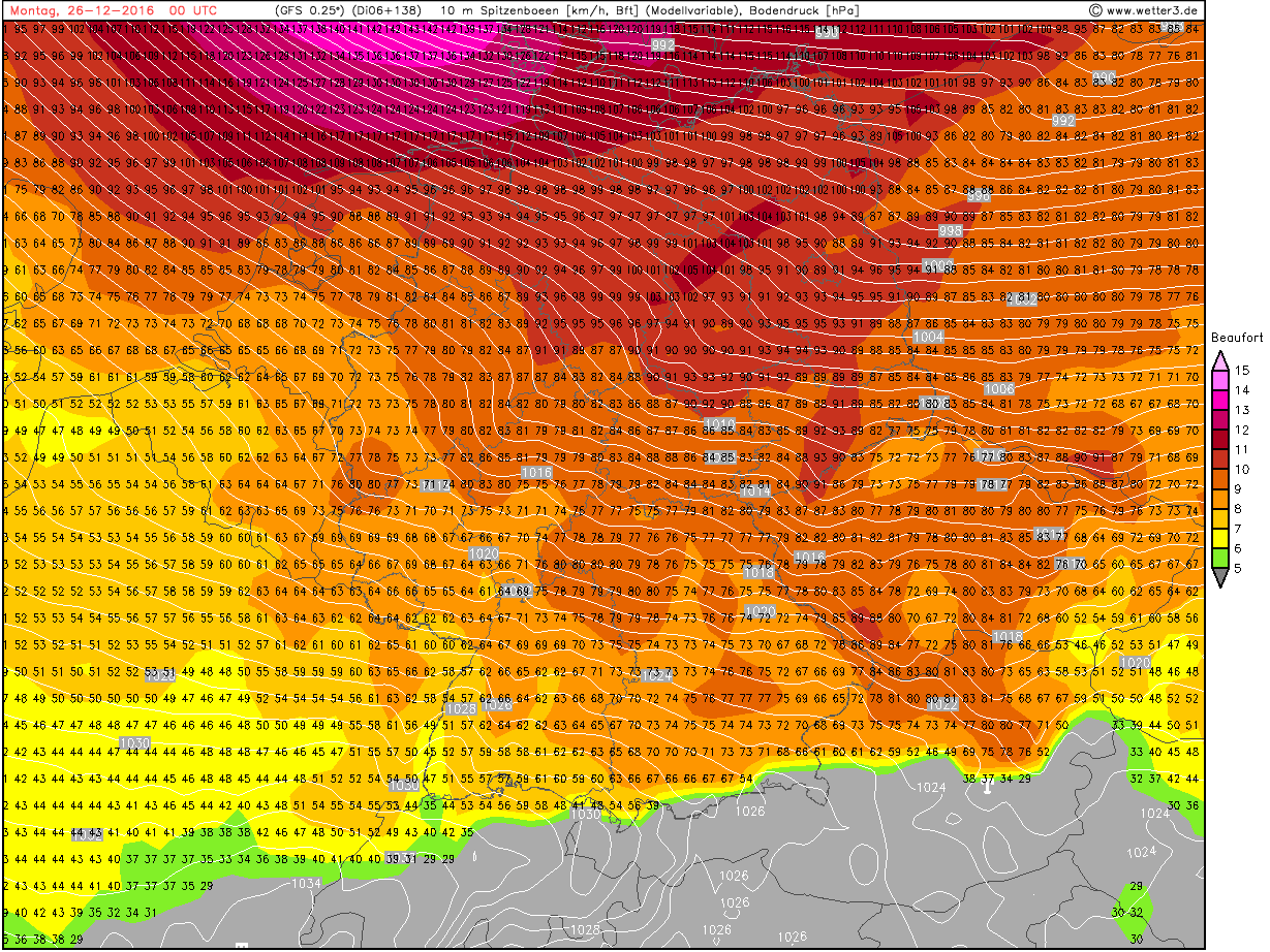
But at the same time, a new storm will form over the northern Atlantic to the west of the British Isles. It is expected to reach Ireland by 00UTC on the 25th, while still intensifying and moving towards the east. Gusts of up to 120km/h are to be expected in Ireland in that night, the UK might experience even higher wind speeds, especially in Scotland. The storm is not predicted to move to the northeast like the previous ones, but rather to keep heading east and cross over southern Scandinavia in the evening of the 25th, bringing extreme wind speeds of over 150km/h to the North Sea close to the shores of mainland Europe (the Netherlands, Germany, Denmark), and also gusts exceeding 120km/h to the Baltic. Unlike the previous storm, this time the storm field is expected to move far inland – Berlin, for example, is currently predicted to be hit by gusts around 110km/h.
The storm is then expected to quickly move away to the east, with a lively, at times stormy wind over most of eastern and eastern central Europe behind it.
That is a brief overview of what is forecast to happen as of now – keep in mind that it is still quite a while away and hence the forecasts may change quite significantly.
This is the ESC European Windstorm Overview, Issued at 0750UTC on the 20.12.2016
There are currently two storm systems in the region.
Severe storm XENIA is located near Iceland with a central pressure of 945hPa and peak gusts exceeding 145km/h. Its storm field is currently affecting Iceland and will move across the UK, Ireland, the North Sea Islands and to the coast of Norway in the coming hours. Hurricane-forced gusts are to be expected in Iceland, the northern UK, the North Sea Islands and Norway’s coast – severe storm warnings have been issued for those regions. In Ireland and parts of the central UK, storm gusts are to be expected and hence a storm warning was issued. The storm may affect the Baltic between 24 and 48 hours from now, however due to uncertainties in the forecast and the time span in which this may happen, only a storm watch has been issued for the islands in the Baltic.
Another storm is currently located in the western Mediterranean, with a central pressure of 1002hPa and peak gusts of over 115km/h. The main threat from this system, however, is excessive precipitation. ESC has issued a storm warning for the Baleares, far southern France, Corsica, Sardinia and Sicily. The storm is forecast to weaken in the coming 24 hours, and no storm watches are necessary.


Dark red: Severe storm warning (>120km/h within 24h likely)
Red: Storm warning (>70km/h within 24h likely)
Yellow: Storm watch (>70km/h within 48h likely)
Wettervorhersage für BERLIN:
HEUTE ist es meist stark bewölkt und zum Teil auch nebelig, erst im Laufe des Nachmittags wird sich die Wolkendecke etwas auflockern und möglicherweise die Sonne auch etwas durchkommen. Die Temperaturen liegen heute Früh bei etwa einem Grad unter null und werden im Tagesverlauf maximal 2°C erreichen. Der Wind wird meist leicht sein, am Abend kann es aber auch Böen nahe 50km/h geben.
MORGEN früh ist es voraussichtlich sonnig, und das wird es, abgesehen von einzelnen Nebelfeldern, auch den restlichen Tag über bleiben. Nach Sonnenuntergang besteht die Gefahr vor FRIERENDEM NEBEL. Die Temperaturen werden von -2 bis +3°C reichen.
Am DONNERSTAG ist es anfangs verbreitet Nebelig – der Nebel kann auch gefrieren und somit für GLÄTTE sorgen. Nachdem sich der Nebel auflöst wird es nochmals sonnig, doch von Westen ziehen besonders in der zweiten Tageshälfte Wolken auf. Am Abend ist dann mit Regen zu rechnen. Die Temperaturen steigen im Laufe des Tages von -1 auf +4°C.
TREND:
Freitag: Meist bedeckt, 2 bis 5°C
Samstag: Regnerisch, 1 bis 7°C
Sonntag: Regen, 4 bis 11°C
Montag: Schauer, 5 bis 6°C
Dienstag: Wechselhaft, 4 bis 7°C
Weather Forecast for DEN HAAG:
TODAY it will be sunny and no precipitation is to be expected. The temperatures will start off around freezing this morning, and will reach maxima of around 5°C. The wind will be light and come from southeasterly directions most of the time.
TOMORROW it will be overcast and especially in the second half of the day, rain is to be expected. The temperatures will be at around 3°C in the morning and reach a maximum of 8°C later during the day. The wind will pick up as well and reach peak gusts of up to 60km/h, with the windiest time being in the morning hours.
THURSDAY will start off rainy, however eventually the precipitation will move away to the east and towards the sunset the sky will start clearing again. The temperatures will range from 5 to 9°C and the wind will be light.
TREND:
Friday: Mostly cloudy, 5 to 8°C.
Saturday: Showers, 7 to 9°C.
Sunday: Rain, 8 to 12°C.
Monday: Partly cloudy, 7 to 8°C.
Tuesday: Partly cloudy, 6 to 8°C.
Forecast for BERLIN
TODAY it will stay overcast and drizzly for the entire day, no sunshine is to be expected. The temperatures will range from 1 to 5°C above freezing, and the wind will be mostly light, coming from westerly directions.
TOMORROW morning there will be some fog especially in the areas surrounding Berlin, which expected to dissolve/lift by noon, leaving a mostly cloudy sky. Towards the evening it may be a little friendlier, with brief periods of sunshine in the afternoon hours before sunset. The temperatures won’t change much over the course of the day, and will hover between 3 and 5°C. The wind will be coming from the east or southeast and will be light.
It will be overcast in the morning on TUESDAY, but later the clouds are expected to move away and give way to sunshine. In the morning, the temperatures will drop slightly below freezing to -1°C, but the maxima will still be around +2°C, above freezing. The wind will continue to be mostly light and the southeasterly flow will persist.
TREND:
Wednesday: Partly cloudy, -1 to +3°C
Thursday: Fair, -1 to +4°C
Friday: Partly cloudy, -1 to +3°C
Saturday: Partly cloudy, 0 to 3°C
Sunday: Mostly sunny, -1 to +5°C
This is the ESC European Windstorm Overview, issued 2016.12.14 at 1630UTC.
There are currently two storm systems in the regions.
Severe storm XENIA is located to the southeast of Iceland with a central pressure of 973hPa and peak gusts exceeding 130km/h. It is currently affecting Iceland, the North Sea Islands and possibly the coast of Norway. The storm is expected to weaken and ultimately dissipate as it moves in a northerly direction and away from land masses. Due to uncertainties in the size of XENIA’s storm field, a storm watch has been issued for the coast of Norway.
A nameless severe storm is located over the central northern Atlantic, with a central pressure of only 959hPa and peak gusts exceeding the impressive value of 160km/h. It is forecast to move further to the northeast but weaken on the way. Iceland should nonetheless brace for gusts above 110km/h from this storm within the 24-48hours. Due to the possibility of storm gusts in northwestern Ireland and the northwestern UK, a storm watch has been issued for those regions as well.
Below are the ESC Overview- as well as the Warnings and Watches Maps.


This is the ESC European Windstorm Overview, issued 12.12.2016 at 1630UTC.
There are currently two storm systems in the region.
Storm WALTRAUD is located at the northeastern tip of Iceland, currently with a central pressure of 980hPa and peak gusts exceeding 115km/h. The storm is currently affecting Iceland, hence a storm warning has been issued for that island. No other land masses are expected to be in WALTRAUD’s storm field within the forecast period.
A nameless severe storm is located over the northern Atlantic, moving to the north. It currently has a central pressure of 960hPa and peak gusts exceeding 140km/h. Its storm field is expected to extend over Iceland, Ireland, the UK and the North Sea islands within the 48-hour forecast period needed for a watch to be issued.
Below are the ESC European Storm Overview and Warnings / Watches maps:


This is the ESC European Windstorm Overview, Issued at 1500UTC on the 07th of December, 2016.
There is currently 1 storm system in the region.
Storm UTE is located to the north of the British Isles with a central pressure of 994hPa and gusts exceeding 105km/h in its storm field. It is currently affecting both the UK and Ireland, hence a storm warning has been issued for these two countries. A storm warning has also been issued for the North Sea islands, where the storm field is expected to move within the next 24 hours. UTE is then predicted to move further to the east, affecting the coasts of southern Scandinavia and the Baltic coasts as soon as within 36 hours; due to uncertainties in timing and intensity of the storm field, a storm watch has been issued. The storm field is then expected to stretch southeast through eastern Europe towards the end of the 48-hour forecast period; a storm watch has been issued for those regions as well. Peak gusts of storm UTE today:
166km/h – Cairngorn Mountains, UK
135km/h – Aonach Mor, UK
128km/h – Bealach Na Ba No 2, UK
Below are the ESC Overview, as well as the Warnings and Watches map:

