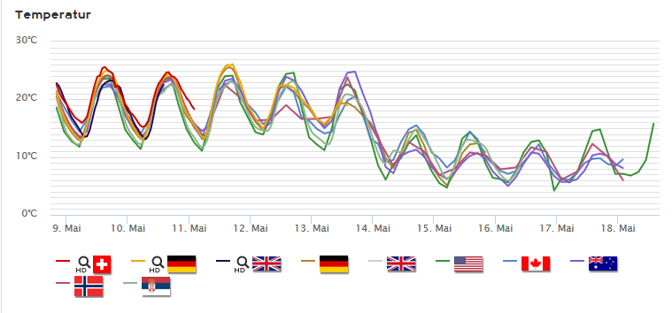
The temperatures currently in central Europe are very nice and warm, partially considered “summer days” in the statistics (>25°C). This nice weather will continue in the coming days – but then a drop in temperature is expected. Below is the trend for Berlin, but it will look very similar in most of central Europe:
The cold weather with many showers is good for something at least in Berlin: rainbows. Here are two photos that were taken in the afternoon of the 27th of April.
Roughly the northwestern third of central Europe might be affected by thunderstorms today. In northwestern Germany these thunderstorms are expected to bring sleet and possible snow, therefore causing dangerous conditions on the roads. Further, large amounts of small hail may fall, and storm gusts are to be expected in the thunderstorms and showers. The risk of tornados is also slightly increased.
ESTOFEX (European Storm Forecast Experiment) has issued a level 2 warning for southwestern France. According to the forecast, the main risks in possible severe thunderstorms are large hail, storm gusts and possibly tornados. Around the level 2 and towards the northwest, including southern France, Switzerland, Austria and southern Germany, a level one was issued. Main risks here are also large hail and storm gusts as well as a slightly increased possibility for tornados. For the same risks, a level 1 was also issued in southeastern Poland. In the northwestern Iberian peninsula, ESTOFEX also issued a level 1, with the main risks being strong rain, storm gusts and large hail.
Aktuell bewegen sich durch den Osten Deutschlands Gewitter. Diese verlagern sich in Richtung Osten und können Sturmböen bis 100km/h sowie Starkregen mit sich bringen.
Currently thunderstorms are moving through eastern Germany. The thunderstorms are moving towards the east and can bring storm gusts up to 100km/h as well as strong rain.
ESTOFEX has issued a level 1 severe thunderstorm warning for eastern Germany. The main risks expected are strong winds and, to a lesser extent, large hail. Below is the ESTOFEX map for today.
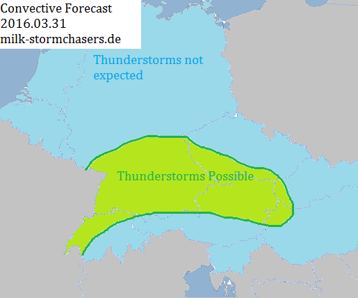
M.I.L.K. has released a convective forecast for Central Europe, valid for today. Thunderstorms are possible in southern Germany, Austria north of the Alps, far western Hungary, southern Czech Republic and western Switzerland today. In other regions of central Europe, thunderstorms aren’t expected.
ESTOFEX (European Storm Forecast) has issued a new convective forecast for today. According to the forecast, thunderstorms are most likely in the Benelux states and northwestern Germany, in eastern Poland, Slovakia, Hungary and far western Ukraine, as well as in southwest France. Level 1 warnings were issued for eastern Poland, Slovakia, Hungary and far western Ukraine, as well as for southeast England, the Benelux states and western / central Germany and southwest France. The main risk in thunderstorms throughout Europe today are strong straight-line winds and large hail.
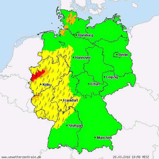
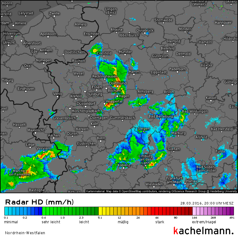
Derzeit ziehen teils recht kräftige Gewitter über Nordrhein-Westfalen. Dabei kann es Böen über 85km/h sowie Starkregen geben, auch kleinkörniger Hagel kann nicht ausgeschlossen werden.
ESTOFEX (European Storm Forecast Experiment) has issued a level one convective weather warning for parts of central Europe today. The warning affects northern France, Belgium, Luxembourg and western and central Germany. The main risks in thunderstorms forming in these areas are isolated tornados and strong straight-line winds. The thunderstorm activity is predicted to increase towards the afternoon, and the convective storms will dissipate after sunset due to the lack of energy.