2017.10.22 / 23 – Wettervorhersage für Berlin / Weather Forecast for Berlin (Deutsch / English – Bilingual)

Forecaster: LH

Wettervorhersage für Berlin & Umgebung, Ausgegeben 2017.10.22 um 19:40 MESZ

Weather Forecast for Berlin & Surrounding, Issued 2017.10.22 at 19:40 CEST (EN version below)


Am MONTAG bleibt es voraussichtlich die meiste Zeit über stark bewölkt oder bedeckt. Trotzdem ist nicht mit Regen zu rechnen; höchstens ein paar Tropfen Nieselregen sind zu erwarten. Dank des grauen Wetters bleibt es allerdings den ganzen Tag über recht unangenehm kühl; in der Früh werden die Temperaturen bei rund 9°C liegen, und tagsüber werden nicht mehr als 11°C erwartet. Der Wind wird aber überwiegend leicht sein, und aus westlichen Richtungen kommen.

Am DIENSTAG gibt es in der Früh noch stellenweise etwas NEBEL (Vorsicht beim Fahren!), und auch tagsüber bleibt es zumindest bedeckt, stellenweise kann sich der Nebel auch länger halten. In der Früh ist mit Temperaturen um 7°C zu rechnen, tagsüber sind bis zu 14°C zu erwarten. Der Wind wird leicht sein und die meiste Zeit aus Süden kommen.

Am MITTWOCH bleibt es weiterhin bedeckt, ab und zu kann es auch etwas Regen geben. Dabei liegen die Temperaturen zwischen 11 und 16°C. Der Wind wird zum Teil recht lebhaft sein und vorwiegend aus Westen kommen.


WEITERE AUSSICHTEN:

Donnerstag: Regnerisch, 13 bis 16°C

Freitag: Regnerisch, 10 bis 13°C, WINDBÖEN

Samstag: Regen, 9 bis 12°C, STURMBÖEN

Sonntag: Regnerisch, 6 bis 11°C, STURMBÖEN

Montag: Wechselnd bewölkt, 2 bis 8°C


++++++++++++++++++++++++ENGLISH VERSION++++++++++++++++++++++++

On MONDAY, it will stay overcast throughout the day. Nonetheless, little to no rain is expected; if anything, a few drops of drizzle may fall. Due to the overcast skies, it will stay rather uncomfortably cool even during the day. The temperatures will start off at around 9°C in the morning and reach no more than 11°C during the day. The wind will be light and come from westerly directions.

On TUESDAY, there will be some regional patches of FOG in the morning (drive carefully!), and also during the day it will stay overcast, with some patches of fog possibly persisting well into the day. In the morning temperatures of around 7°C are to be expected, later up to 14°C may be reached. The wind will be light and will be coming from the south.

On WEDNESDAY, it will continue to be overcast, from time to time there may also be some rain. The temperatures will be ranging from 11 to 16°C. The wind may be quite lively at times and the dominant direction will be west.


TREND:

Thursday: Rainy, 13 to 16°C

Friday: Rainy, 10 to 13°C, WIND GUSTS

Saturday: Rain, 9 to 12°C, STORM GUSTS

Sunday: Rainy, 6 to 11°C, STORM GUSTS

Monday: Partly cloudy, partly sunny, 2 to 8°C

2017.10.16 – ESC: (ex) Hurricane OPHELIA to make Landfall in Ireland, UK

Hurricane-forced storm OPHELIA will make landfall in Ireland within the coming few hours. The storm, which used to be a hurricane further south over the Atlantic and continues to be tracked by the US’ National Hurricane Center, will come ashore packing winds comparable to those found in major hurricanes of the category three.

OPHELIA is currently located to the south-southwest of Ireland, with a central pressure of 963hPa (at 00UTC) and peak gusts exceeding 200km/h. The storm is not expected to weaken significantly before striking Ireland, and the wind field is expected to be large enough to also affect GB.

Gusts of around 200 km/h are expected throughout much of Ireland, and gusts exceeding 120km/h and reaching up to 180km/h are to be expected in GB, especially in Scotland, as well. It is an unusually powerful storm and has serious potential to cause damage and loss of life. Locals should follow all recent developments.

Aside from strong wind, waves that may reach up to 12 meters in height are expected to batter the southern coast of Ireland.

Below are the ESC European Windstorm Overview, as well as the warnings & watches. Due to the special situation, you will also find additional maps and information on storm OPHELIA.

Correction: The storm is named OPHELIA, not ORPHELIA.


2017.10.05 – Deutsch: Orkan XAVIER in Berlin – Die derzeitige Vorhersage

Sturm / Orkan XAVIER wird heute mit hoher Geschwindigkeit und Orkanböen über Deutschland hinweg fegen. Dabei liegt auch Berlin in dem Streifen, der voraussichtlich den meisten Wind abbekommen wird. Hier eine schnelle Übersicht darüber, was die Vorhersagemodelle derzeit berechnen.

Derzeit liegen das Zentrum und die meisten Sturmböen von XAVIER noch über der Nordsee, allerdings erreichen bereits erste Sturmböen die niederländische und belgische Küste. In Berlin kommt der Sturm erst am Nachmittag so richtig an, dann aber möglicherweise durchaus mit etwas Wucht.

Der Deutsche Wetterdienst hat einen Streifen von der Nordsee südostwärts durch Deutschland gezogen, in dem eine Warnung vor orkanartigen Böen besteht – auch Berlin liegt in dieser Zone. Der DWD selber rechnet für Berlin mit Böen zwischen 90 und 115km/h, die anfangs as westlicher, später aus nordwestlicher Richtung kommen werden.

Die unterschiedlichen Vorhersagemodelle sind sich aber noch ziemlich uneinig darüber, wie stark der Wind heute wirklich wird, und zum Teil sogar darüber, wann es am windigsten sein wird. Einig sind sie sich darin, dass im Laufe des Nachmittags mit Sturmböen gerechnet werden muss. So rechnet das Amerikanische Vorhersagemodell um rund 15:00 mit der Spitze des Sturmes und Sturmböen bis knapp 90km/h. Das Schweizer- wie auch das Australische und Deutsche Vorhersagemodell rechnen damit, dass es um 17:00 am windigsten wird, rechnen aber mit “nur” 70 bis 80km/h. Die Deutschen und Britischen “HD-Vorhersagemodelle” die Kachelmannwetter anbietet sind derzeit am pessimistischsten, und rechnen mit Böen um 110km/h um 18:00.

Was nun wirklich eintritt, bleibt abzuwarten. Orkan XAVIER bewegt sich sehr schnell, und schon kleine Unterschiede in der Zugbahn können große Auswirkungen darauf haben, wie stark der Sturm in unterschiedlichen Gebieten ausfallen wird. Halten Sie sich über die aktuelle Entwicklung informiert, und seien sie vorsichtig – halten Sie sich von Bäumen fern und sichern Sie lose Gegenstände.

Windspitzen, die von unterschiedlichen Vorhersagemodellen derzeit für Berlin erwartet werden. Quelle: Kachelmannwetter.de

2017.10.04 – ESC European Windstorm Update (Bilingual): Storm XAVIER to strike Germany & Central Europe /// Sturmtief XAVIER wird über Deutschland & Mitteleuropa hinwegfegen

DEUTSCHE VORHERSAGE UNTER DER ENGLISCHEN!

For the sake of enabling a detailed analysis of the predicted path of storm XAVIER, we will focus on this storm in this European Windstorm Update. Warnings & Watches as well as the overview of other ongoing storms in & around Europe can be found on the maps below.

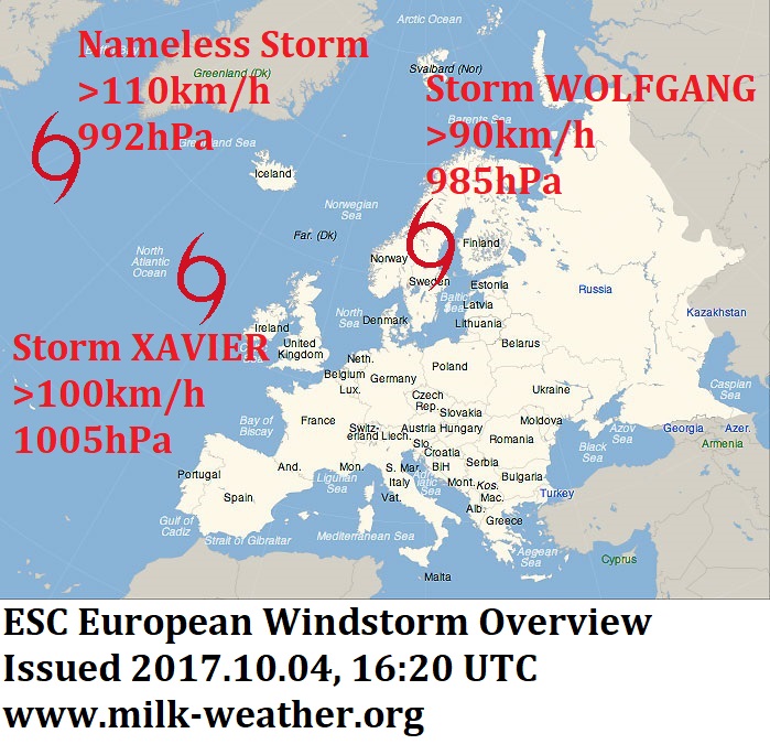
Storm XAVIER is currently located to the northwest of Ireland, with wind peaks exceeding 100km/h and a current central pressure of 1005hPa. Currently, the storm is little more than a normal autumn low pressure system over the Atlantic, and though it will bring a windy night to the UK and Ireland, it will only really start to intensify over the North Sea in the second half of the night. The storm is – and will stay – fairly compact, and there are still uncertainties regarding where the storm field will be when and how strong it will be in different places at different times, but this is the latest forecast:

The Predicted Path

Storm XAVIER will rapidly intensify over the North Sea after it has crossed the British Isles, turning from a regular Storm into a “severe storm” (a category reserved for storms packing hurricane-forced gusts). Serious storm gusts will first make landfall on the Dutch and Belgian coasts in the morning hours between 4 and 6 am local time, with gusts around 110km/h expected along much of the coast. The storm will continue to intensify and wind speeds may continue to increase throughout the morning.
As the morning progresses, the wind field will start moving further inland, with storm gusts between 70 and 90km/h expected in much of the Netherlands and the first storm gusts arriving in western Germany.
Around noon or in the early afternoon, the area with the most intense wind will have moved on from the Netherlands to Germany, and the storm may temporarily lose a bit of strength, though storm gusts around 90km/h are nonetheless expected throughout much of northwestern Germany.
HOWEVER, as the storm moves eastward across Germany, it is expected to quickly re-gain energy within only a few hours, with gusts around 110km/h to be expected in much of central Germany, and wind peaks likely to well exceed 120km/h in exposed locations (such as the Brocken mountain and the mountains of Saxony).
The storm will continue to move in the general direction of east-southeast, and in the later afternoon gusts ranging anywhere from 90 to over 130km/h are expected throughout most of Eastern Germany, including Berlin. The mountains of Saxony are likely to be exposed to especially harsh conditions, but serious wind speeds are expected for all other areas of eastern Germany at this time as well.
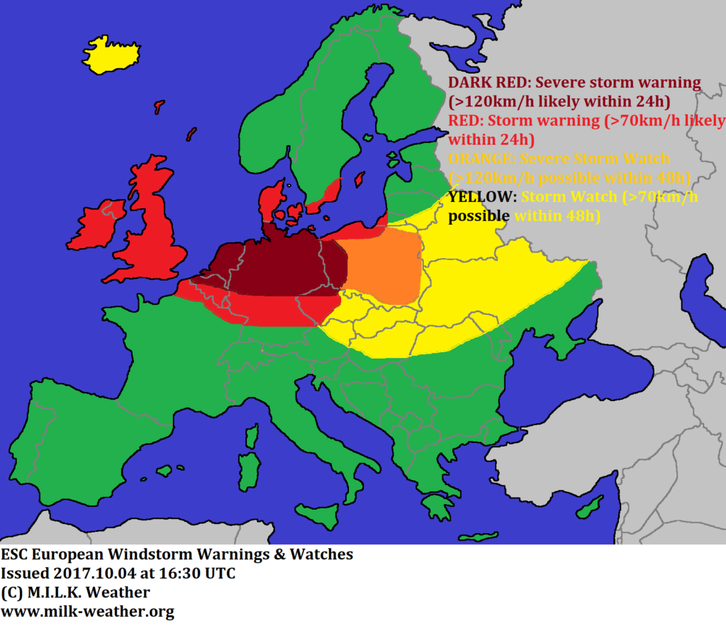
As the sun sets, the wind field will move into Poland and will start to calm down in Germany. Storm watches have been issued for eastern Europe, including Poland. See the map below for more details.

Risks

Trees, branches, scaffolding, roof shingles and lose objects may fall and be blown around. In the city also beware of objects that may potentially be blown off balconies. There may be a significant impact on transportation on the road and railway networks, flight delays or even cancellations. Stay indoors when possible, and keep clear of trees.

#################################

Um eine detaillierte Analyse der erwarteten Zugbahn von XAVIER zu ermöglichen, werden wir uns in dieser Vorhersage auf diesen Sturm konzentrieren. Warnungen, Vorwarnungen und eine Übersicht über aller derzeitigen Stürme in & um Europa können Sie auf den Karten unten finden.

Sturm XAVIER liegt derzeit nordwestlich von Irland, mit Windspitzen um 100km/h und einem derzeitigen Luftdruck von 1005hPa in seinem Zentrum. Damit ist XAVIER derzeit nicht viel mehr als ein gewöhnlicher Herbststurm, der in der kommenden Nacht etwas wind nach Irland und Großbritannien bringen wird. Erst in der zweiten Nachthälfte wird der Sturm anfangen sich rasant zu verstärken. Der Sturm ist relativ kompakt, und wird das voraussichtlich auch bleiben; so gibt es noch Unsicherheiten darüber wann, wo, und wie stark der Sturm genau treffen wird. Hier ist allerdings der neuste Stand der Vorhersagen:

Die Vorhergesagte Zugbahn

Nachdem XAVIER die Britischen Inseln überquert hat, wird er sich über der Nordsee rasant verstärken und sich von einem normalen Sturm in einen Orkan (mit Böen über 120km/h) verwandeln. Orkanartige Böen um 110km/h werden zwischen 4 und 6 in der Früh Ortszeit in Holland und Belgien die Küste erreichen. Der Sturm wird sich dann in den kommenden Stunden voraussichtlich weiter verstärken, und auch die Windgeschwindigkeiten können noch etwas steigen.
Im weiteren Verlauf des Morgens wird das Sturmfeld anfangen, sich weiter landeinwärts zu verschieben, und Sturmböen zwischen 70 und 90km/h sind in den gesamten Niederlanden zu erwarten. Der ersten Sturmböen werden außerdem im Nordwesten Deutschlands ankommen.
Rund um Mittag oder am frühen Nachmittag wird sich der Schwerpunkt des Sturmes von den Niederlanden nach Nordwestdeutschland verlagern, und XAVIER wird womöglich temporär etwas an Kraft verlieren – es ist aber weiterhin verbreitet mit Sturmböen um 90km/h im Nordwesten zu rechnen!
ALLERDINGS: während sich der Sturm weiter ostwärts über Deutschland bewegt, wird XAVIER innerhalb weniger Stunden wieder schnell Energie gewinnen, und mit verbreitet orkanartigen Böen um 110km/h – sowie Böen weit über 120km/h in exponierten Lagen – Mitteldeutschland heimsuchen (der Brocken und das Erzgebirge werden vermutlich besonders hohe Windgeschwindigkeiten abbekommen).
XAVIER wird sich im Laufe des Nachmittags weiter nach Südsüdosten verlagern, und am späteren Nachmittag ist im gesamten Osten Deutschlands mit Böen zwischen 90 und 130km/h zu rechnen. Auch Berlin wird von dem Sturm betroffen sein. Das Erzgebirge wird voraussichtlich besonders heftigen Sturmböen ausgesetzt sein, allerdings werden in Ostdeutschland überall orkanartige Böen zu erwarten sein.
Am Abend wird sich das Sturmfeld von Deutschland nach Polen verlagern und der Wind wird sich in Deutschland wieder etwas beruhigen. Entsprechende Vorwarnungen sind auf der Karte unten zu finden.

Gefahren

Bäume, Äste, Baugerüste, Dachziegel und lose Gegenstände können fallen oder herum geblasen werden. Seien Sie in der Stadt außerdem vorsichtig vor Dingen, die von Balkonen stürzen können. Es kann zu teils erheblichen Behinderungen auf der Straße und auf den Schienen kommen, sowie zu Verspätungen und Ausfällen im Flugverkehr. Wenn möglich, bleiben Sie drinnen. Halten Sie sich unbedingt von Bäumen fern.


Below, you will find the ESC European Windstorm Overview, as well as the Windstorm Warnings & Watches.


2017.10.01 – ESC European Windstorm Update: Storm WOLFGANG to strike British Isles

There are currently two storm systems tracked by ESC. The remains of Hurricane LEE have entered the forecast area, currently with a central pressure of 992hPa but still exceeding peak gusts of 115km/h. LEE, however, is expected to weaken within the next 24 hours and will likely not be considered a storm system in the next update.

The second storm currently being tracked is storm WOLFGANG. WOLFGANG will continue to intensify in the coming hours, and as soon as in 3 hours may be considered a “severe storm”, which gusts exceeding 120km/h. Currently, WOLFGANG’s central pressure is 977hPa and peak gusts are exceeding 110km7h.
The wind field of WOLFGANG is expected to move east in the coming 24 hours. A severe storm warning has been issued for large parts of Ireland and the UK, meaning that gusts above 120km/h are to be expected in these areas when WOLFGANG strikes. The peak of the storm is generally expected to happen in the coming night. A severe storm warning has also been issued for the southern and southwestern coasts of Norway and the islands of the North Sea.
A storm warning has been issued for both Ireland and the UK, as gusts exceeding 70km/h are likely to take place all over the islands.
A storm watch has been issued for Denmark, as there is still uncertainty when the wind field will reach the country. Storm gusts may begin in the final hours of the coming night, or may only start moving in over the course of tomorrow.
A storm watch has also been issued for the Baltic Islands as storm gusts are expected to strike these areas tomorrow, and there is a slight chance for a storm watch to be extended to the Baltic Coasts tomorrow.

Below are the ESC European Windstorm Overview, Warnings and Watches.


2017.09.28 – ESC European Windstorm Overview: Severe Storm VICTOR set to miss most of UK, Ireland

Severe storm VICTOR is currently located to the west of Ireland. The storm is packing peak gusts of over 130km/h and has a central pressure of 974hPa, according to the 00UTC analysis of the UK Met Office. The storm has crossed the Atlantic towards the east, however it looks like it will be deflected by the general high pressure over mainland Europe and will miss most of the UK and Ireland.

However, a storm warning has been issued for the northern and northwestern coasts of both the UK and Ireland, as it is likely that storm gusts will take place there as the storm passes to the north throughout the coming 24 hours. A storm watch has been issued for Iceland, as there is uncertainty as to where and how strong the wind field of VICTOR will be in 24 to 48 hours. A storm warning has also been issued for the islands of the North Sea, as generally windy conditions caused by the overall location of highs and lows over Europe will continue.

Below are the European Windstorm Overview, Warnings & Watches, and Satellite maps:

2017.09.22 – ESC European Windstorm Update: Storm headed for the UK, Ireland and Iceland

A new storm system has formed over the northern Atlantic. It is a well-defined low pressure area with a central pressure of 980hPa and gusts currently exceeding 110km/h. It has crossed the Atlantic eastwards on a direct course to the British Isles, but will be deflected by the high pressure system over mainland Europe so that the UK will be largely spared.

There is still a lot of uncertainty about where, when and with what intensity the storm field will reach land. A storm watch has been issued for all of Ireland, and storm gusts may arrive at the western coast as early as this evening. Tomorrow, storm gusts are possible throughout Ireland and in the northwestern parts of the UK. Towards the end of the 48-hour forecast period, the storm will reach Iceland. It is possible that the storm intensifies on the way there and then brings hurricane-forced gusts exceeding 120km/h to the island, hence a severe storm watch has been issued for Iceland.

Below are the ESC European Windstorm Overview, Warnings & Watches as well as a satellite image of the storm.


2017.09.21 – ESC European Windstorm Center Update: A new storm coming from the west

Currently there is one storm within the area that the ESC covers. This nameless severe storm’s core is located between Iceland and Greenland, where there are currently wind gusts exceeding 130km/h over the open ocean. The central pressure of the storm was 987hPa at the latest 00UTC analysis.

However, a storm watch has been issued for Ireland and Iceland due to a different storm. A new storm is expected to form tomorrow before crossing the Atlantic and potentially reaching Iceland & Ireland towards the end of the 48-hour forecast period. According to current forecasts, the storm will not strike mainland Europe but rather be deflected towards the north by the high pressure area over central Europe.

Below are the maps:


2017.09.13 – European Windstorm Center: Severe Storm SEBASTIAN strikes central Europe / Sturm SEBASTIAN trifft Mitteleuropa

Forecaster: LH

Severe Storm SEBASTIAN will strike mainland Europe today, bringing storm gusts to large parts of western and central Europe and hurricane-forced gusts to the coasts and other exposed locations.
The storm’s center is located over the UK, with a central pressure of 982 hPa, at the latest (00UTC) analysis by the UKMetOffice. The highest gust of storm SEBASTIAN so far today was 124km/h in Bologne-sur-Mer, France, followed by 119km/h in Mumbles, UK. These values will likely be topped throughout the day.

Hurricane-forced gusts over 120km/h are to be expected along the coast of the Netherlands and Germany as well as in Denmark. Storm gusts are likely throughout large parts of Europe, including much of France, Belgium, Luxemburg, Germany, Czech Republic and Poland.
Uncertainty exists about the possibility for storm gusts in southern Sweden, hence a watch has been issued.
The coasts of the eastern Baltic Sea have been placed under a storm watch as storm-forced gusts are expected to move into the area between 24 and 48 hours from now.

+++++++++++++++++++++++++++++++DEUTSCH++++++++++++++++++

Sturm SEBASTIAN trifft heute auf Mitteleuropa und wird Sturmböen, in exponierten Lagen sogar Orkanböen mit sich bringen.
Das Zentrum des Sturmes befindet sich in der letzten UKMetOffice Analyse von 00UTC über England mit einem Kerndruck von 982 hPa. Die stärkste Böe, die SEBASTIAN bislang heute verursacht hat erreichte 124km/h und wurde in Bologne-sur-Mer, Frankreich, gemessen. 119km/h wurden aus Mumbes, GB gemeldet. Im Laufe des Tages werden diese spitzen höchstwahrscheinlich noch übertroffen.

Orkanböen über 120km/h sind an den Küsten der Niederland und Deutschlands sowie in Dänemark zu erwarten. Sturmböen sind in weiten Teilen Europas wahrscheinlich, inklusive großen Teilen Frankreichs, Belgiens, Luxemburgs, Deutschlands, der Tschechischen Republik und Polens.
Es besteht noch Unsicherheit darüber ob und wie stark Sturmböen in Süd-Schweden auftreten werden, deswegen wurde ein “storm watch” ausgegeben.
Für die Küsten der östlichen Ostsee wurde ebenfalls eine “storm watch” ausgegeben, da Sturmböen hier circa in 24 bis 48 Stunden ankommen wird.


2017.09.10 – Update: 18 UTC – Storm REINHOLD reaching Ireland, UK

Wind speeds are picking up in Ireland and the UK as storm REINHOLD is approaching the British Isles ahead of a stormy night.

A peak gust of 104km/h has already been registered in Mace Head, Ireland, and all stations reported gusts over 65km/h between 18 and 19 UTC, with many reporting gale- or storm-forced gusts.
Much of the UK is also preparing for a stormy night. A 100km/h gust was measured at the Cairnwell Station in Scotland, and the peak gust of the past hour, at 87km/h, was registered in Langdon Bay on the far southeastern coast of England.