2018.02.09 – ESC European Windstorm Update: Storm ONDRA headed for the UK, Ireland, Iceland

In today’s ESC European Windstorm Update, the overall situation in Europe is rather calm. There is currently only one storm system that is being tracked.

Storm ONDRA is currently located out over the North Sea, with a central pressure of 974hPa. Peak gusts in the storm are currently estimated to exceed 120km/h, classifying it as a “severe storm”. The storm is expected to head roughly east or northeast, with the most severe gusts in the next 24 hours to be expected on the islands of the North Sea and in Iceland (in that order). Storm gusts are also to be expected in much of Ireland and the UK within the next 24 hours.
A separate low-pressure system is expected to form roughly around the English Channel between 24 and 36 hours from now, which will bring storm gusts or even severe storm gusts to the coasts of Belgium, the Netherlands, the German North Sea coast, Denmark, and Norway. Storm Watches have been issued accordingly. See below.

Below are the ESC European Windstorm Overview, as well as the European Windstorm Warnings & Watches.


2018.01.18 – Severe Storm FRIEDERIKE Summary (Orkan Friederike)

Severe Storm FRIEDERIKE (Orkan Friederike) moved through the Benelux and over Germany today, and is now moving into Poland and the Czech Republic. As predicted, the storm intensified over the North Sea after it crossed the British Isles, however it intensified more than was predicted by most forecast models.
As of now, between 3 and 5 people are reported dead because of the storm.
In Germany, all long-distance trains were canceled and in some regions, all train service was terminated.
The Amsterdam Schiphol airport in the Netherlands canceled all flights due to the severe wind; this and the impact of the storm on other flight operations caused significant delays and cancellations throughout Europe.
Countless trucks were overturned, trees were uprooted and buildings damaged; there is currently no reliable figure as to the approximate amount of damage.

Peak gusts of Orkan Friederike (between 00 and 19:00 UTC):
205km/h – Brocken (Mountain), Germany
174km/h – Fichtelberg (Mountain), Germany
165km/h – Pilatus (Mountain), Switzerland
159km/h – Cap Corse, France
158km/h – Zugspitze (Mountain), France
156km/h – Säntis (Mountain), Switzerland
155km/h – Milesovka (Mountain), Czech Republic
154km/h – Jungraujoch (Mountain), Switzerland
148km/h – Feuerkogel (Mountain), Austria
144km/h – Hoek Van Holland, Netherlands
144km/h – Kahler Asten (Mountain), Germany

Peak gusts of Orkan Friederike, registered <600m above sea level:
159km/h – Cap Corse, France
144km/h – Hoek Van Holland, Netherlands
141km/h – Capel Curig, UK
141km/h – Ile Rousse, France
137km/h – Gera/Leumnitz, Germany
135km/h – Weinbiet/Pfalz, Germany
130km/h – Erfurt/Bindersleben, Germany
128km/h – Leipzig/Halle, Germany
126km/h – Aberdaron, UK
126km/h – Le Goeree, Netherlands
126km/h – Ahaus, Germany
126km/h – Münster/Osnabrück Flughafen, Germany
126km/h – Bückeburg, Germany
126km/h – Niederrhein/Flughafen, Germany

2018.01.18 – Wettervorhersage für Berlin / Weather Forecast for Berlin

Wettervorhersage für Berlin, Ausgegeben 2018.01.17 um 17:30 MEZ

Weather Forecast for Berlin, Issued 2018.01.17 at 17:30 CET (English Version Below)


Am DONNERSTAG bleibt es meist bedeckt. Am Nachmittag ziehen dann von Westen her Niederschläge auf, die anfangs noch als Schnee, später dann aber als Regen fallen werden. Die Temperaturen werden in der Früh mit 1°C nur knapp über dem Gefrierpunkt liegen, und werden tagsüber voraussichtlich Höchstwerte von etwa 4°C erreichen. Der Wind wird besonders am Nachmittag und Abend stark bis stürmisch sein, und es muss mit STURMBÖEN um 90km/h gerechnet werden.

Am FREITAG beruhigt sich das Wetter dann wieder etwas. Allerdings bleibt es weiterhin meist bedeckt oder zumindest stark bewölkt, und vereinzelt kann es auch– besonders in der Früh – Schneeschauer geben. Die Temperaturen werden von 0 bis 3°C reichen, und der Wind wird meist leicht sein.

Am SAMSTAG ist es in der ersten Tageshälfte überwiegend stark bewölkt bis bedeckt, immer wieder kann es auch Schneefälle geben. Am Nachmittag lockert es dann aber voraussichtlich auf. Die Temperaturen werden in der Früh bei -2°C liegen und tagsüber maximal +1°C erreichen, und der Wind wird leicht sein.


WEITERE AUSSICHTEN:

Sonntag: Wechselnd bewölkt, -5 bis +1°C

Montag: Wechselnd bewölkt, -2 bis +3°C

Dienstag: Regnerisch, 4 bis 10°C

Mittwoch: Wechselnd bewölkt, 5 bis 10°C

Donnerstag: Bedeckt, 5 bis 9°C


+++++++++++++++++++++++++++++ENGLISH VERSION++++++++++++++++++++

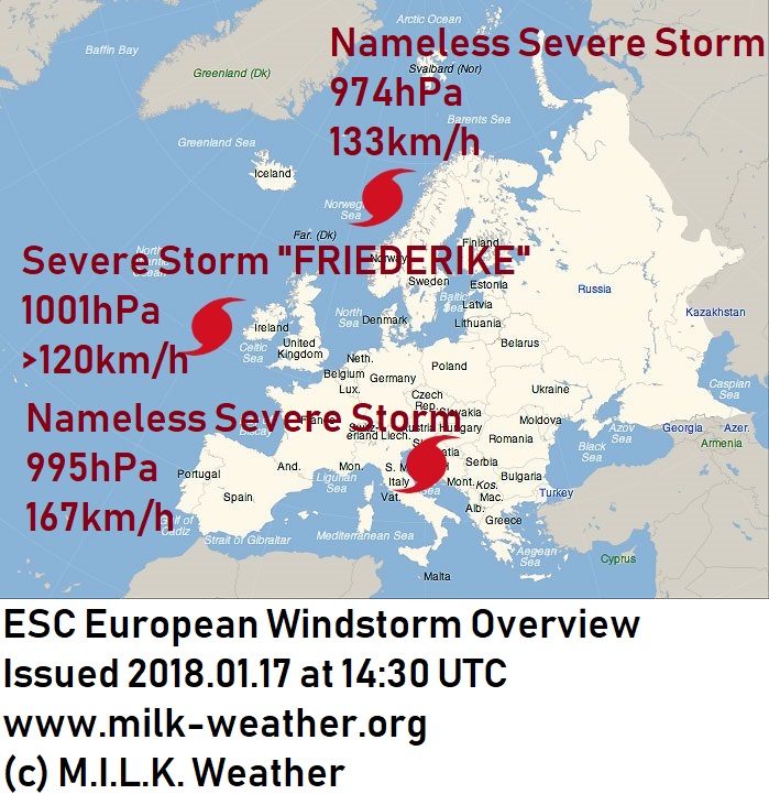
On THURSDAY, it will stay largely overcast, and in the afternoon precipitation will move in from the west, which will initially fall in the form of rain, but later change to rain. The temperatures will start off only slightly above freezing at 1°C in the morning, and are expected to reach a high of 4°C. The wind will be lively or stormy and will pick up especially in the afternoon and evening; STORM GUSTS of around 90km/h are to be expected. More on the storm here: https://milk-weather.org/blog/?p=1951

On FRIDAY, the weather will calm down a bit. However, it will nonetheless stay mostly overcast or at least mostly cloudy, and at times – especially in the morning – there may also be snow showers. The temperatures will range from 0 to 3°C, and the wind will be mostly light.

SATURDAY will start off with overcast skies, time and again there can also be periods of snowfall. In the afternoon, the sky is expected to clear up. The temperatures will lie at around -2°C in the morning, and will reach +1°C during the day, and the wind will be light.


TREND:

Sunday: Partly cloudy, partly sunny, -5 to +1°C

Monday: Partly cloudy, partly sunny, -2 to +3°C

Tuesday: Rainy, 4 to 10°C

Wednesday: Partly cloudy, partly sunny, 5 to 10°C

Thursday: Overcast, 5 to 9°C

2018.01.17 – ESC European Windstorm Update: Storm FRIEDERIKE expected to slam Europe, Storm ongoing in Mediterranean

A couple of stormy days are ahead for much of Europe – we will take a look at the specifics in this ESC European Storm Center update.

Three storm systems are currently spread across the map. Of note, other than storm FRIEDERIKE, is a low-pressure system located over the Balkans which will bring severe storm gusts to much of the eastern Mediterranean & the coasts of the Black Sea.

Storm FRIEDERIKE (named Storm FIONN in the UK), currently off the western coast of Ireland, is expected to further intensify as it heads for mainland Europe; within the coming 12 hours, the storm will cross Ireland and the UK and start making landfall in northwestern France. It is expected to move across much of western and central Europe, packing gusts of potentially up to 200km/h.

Ireland: Wind speeds will first start noticeably picking up in southwestern Ireland within the next few hours, and by tonight at 18:00 UTC, gusts are expected to be exceeding 110km/h in the far southwest. Later in the evening, similar wind speeds are to be expected for much of the western and southern coast. By midnight, much of Ireland (with exception of the North) will experience the full force of the storm, with gusts expected to well exceed 120km/h even far inland. Peak gusts for Dublin are expected to be at around 100km/h. The wind will start calming down starting in the west in the early morning hours.

United Kingdom: storm gusts are expected to reach the far southwest of the country by tonight at 21:00UTC, and by midnight much of Wales and the southwest of England are expected to have full storm-force gusts. In the hours following midnight, hurricane-forced gusts well beyond 120km/h are expected at the western, but also potentially the southern coast of the island. In the morning hours before sunrise, gusts exceeding 130km/h are expected in Wales and much of England, even far inland and away from exposed locations. The wind will start calming down in the west at around 06:00 UTC on Thursday, however severe storm gusts are expected to persist in the east until several hours later.

France: Storm gusts will reach the northwestern coast over the course of the evening, exceeding 110km/h in many locations by 21:00 UTC. Such severe storm gusts will mostly stay limited to the coast, however, and further inland (including in Paris), “only” regular storm gusts between 70 and 90km/h are to be expected. The wind will persist until well into the morning, with peak gusts near 130km/h expected at the northern coast and in the far north of the country, and gusts of up to 110km/h likely to be registered further inland.

Benelux: Wind speeds will start picking up in Belgium and the far southwestern Netherlands at roughly 05:00 CET, and severe storm gusts will reach the coast roughly two hours later. By 09:00, much of the Benelux states are expected to have strong storm gusts exceeding 110km/h, with speeds at the coast well above 125km/h. The storm is expected to intensify as it crosses over the North Sea in the morning hours, and gusts of around 130km/h even inland, as well as gusts nearing 160km/h at the coast are not to be ruled out. Peak wind speeds are expected at the Belgian coast at roughly noon, and between 11:00 and 13:00 in the Netherlands, where gusts of 140km/h may be widespread at the coast, and gusts of 120km/h or above are to be expected in much of the southern half of the country. Peak gusts in Den Haag may be anywhere from 110 to 140km/h according to latest predictions, 120km/h are expected for Rotterdam, 100 to 120km/h in Amsterdam. The wind will calm down, starting in the west, in the afternoon and should be largely back to normal before sunset.

Germany: Western Germany will start feeling the effects of storm FRIEDERIKE by 10:00am at latest, with gusts starting to reach speeds near 100km/h. Wind speeds will start approaching and locally exceeding 120km/h in western Germany by noon or the early afternoon hours. By 16:00 CET, the main wind field of the storm will have reached central Germany, still packing gusts of 120km/h or potentially more. Northern Germany, e.g. Hamburg, will stay unaffected by the wind field, however the far south, including Bavaria and Baden-Württemberg, should brace for gusts in excess of 100 or even 110km/h. In the evening, the storm will move towards the east, mainly affecting Hessen and Saxony, where gusts of more than 120km/h are to be expected. Strong storm gusts will continue to pose a risk in Bavaria in the evening as well.

Czech Republic, Southern Poland, Austria, Switzerland: The predictions for these regions are still fairly uncertain, however the Czech Republic and Southern Poland will face wide-spread storm gusts around 100km/h and potentially nearing 120km/h after the storm passes over Germany. In Switzerland, and especially in Austria, severe storm gusts are to be expected on the mountains. In Austria, storm gusts of around 100km/h are also predicted for the lowland north of the Alps.


2018.01.13 – ESC European Windstorm Update: Hurricane-Forced Wind in Iceland

Windy conditions are nothing unusual in Iceland, thanks to its exposed position in the Northern Atlantic. However, the coming days promise to bring wind speeds that may cause complications even in Iceland.

A nameless severe storm system, currently located on the eastern coast of Greenland with a central pressure of 964 hPa, is expected to gradually move towards Iceland and further intensify. Wind peaks are calculated to exceed 145km/h currently, and are expected to reach up to 180km/h within the 48-hour forecast period.

Therefore, a severe storm warning has been issued for Iceland, but also for the island of the North Sea; in these areas, one should brace for some very rough conditions between 12 and 48 hours from now.
A severe storm watch has been issued for the coast of Norway, as the storm system’s severe storm gusts may affect it between 24 and 48 hours from now.
A storm watch has been issued for the British Islands, as the outskirts of this storm will move across the islands between 24 and 48 hours from now, however at much lower intensity than in the other areas.

Below, you will find the ESC European Windstorm Overview, Warnigns & Watches


2017.01.05 – ESC European Windstorm Update: The Calm after the Storm

Storm BURGLIND, which dominated Central European weather for the past few days, has moved off and dissipated into little more than a slight atmospheric depression. Storm gusts persisted, however, especially in the Alps, where peak gusts of close to 150km/h have been registered today thanks to a storm located in the North Sea and named CHRISTINE. The storm has a central pressure of 983 hPa, however is expected to weaken and not be a significant threat to any region. Nonetheless, a storm warning has been issued for the coasts of Germany and the Netherlands, and a storm watch has been issued for much of central Europe.
A second storm is currently located over the northern Atlantic; storm ALJA, at a central pressure of 995 hPa. Peak gusts in this system currently exceed 130km/h, however the storm is expected to lose force and not post a significant threat to the British Isles.
Also of note: A storm warning has been issued for the islands of the North Sea, as stormy conditions are expected there today, and Iceland has been placed under a storm watch for the possibility of increased wind speeds between 24 and 36 hours from now.

Below you will find the European Windstorm Overview, as well as the issued storm warnings & watches.


2018.01.03 – ESC Orkan-Update: Sturm BURGLIND wütet in Mitteleuropa (Deutsche Version)

Orkan BURGLIND, derzeit mit einem mittleren Luftdruck von 966hPa, trifft heute auf Mitteleuropa – und das mit ziemlicher Wucht. Spitzenböen von bis zu 174km/h wurden bereits an der Wetterstation auf dem Gipfel des deutschen Berges Zugspitze gemessen, und Orkanböen sind auch in weiten teilen des Deutschen, Benelux und Französischen Flachlandes zu erwarten. Sturmböen werden in einem noch größeren Gebiet zu erwarten sein. Nach derzeitigen Vorhersagen wird der Sturm innerhalb von 24 Stunden nach Osten abziehen, doch der nächste Sturm ist möglicherweise nicht fern; schon jetzt befindet sich ein weiteres Tief mit dem Namen CHRISTINA über dem Atlantik, welches zumindest auf den Britischen Inseln erneut für etwas Sturm sorgen könnte.

Derzeitige Spitzenböen durch BURGLIND:
174km/h – Zugspitze, Deutschland
161km/h – Great Dun Fell, UK
161km/h – Säntis, Schweiz
152km/h – La Dole, Schweiz
150km/h – Jungfraujoch, Schweiz
144km/h – Napf, Schweiz
144km/h – Pilatus, Schweiz
140km/h – Vlissingen, Niederlande

Unten finden sie die ESC Orkan-Übersicht sowie die Sturmwarnungen und Sturmvorwarnungen.

2018.01.03 – ESC European Windstorm Update: Severe Storm BURGLIND slams Central Europe (English Version)

Severe Storm BURGLIND, with a central pressure of 966 hPa, is striking central Europe today – and striking hard. Peak gusts of 174km/h have already been registered on the peak of the Zugspitze mountain in southern Germany, and full hurricane-forced gusts are expected also in the lowland throughout much of Germany, the Benelux and France. Storm gusts are expected to affect a much broader area. The storm is predicted to move off towards the east within the next 24 hours, however the next storm may not be far away; a low-pressure system by the name of Christina is already approaching over the northern Atlantic, and is expected to bring stormy conditions at least to the UK.

Current peak gusts of storm BURGLIND:
174km/h – Zugspitze, Germany
161km/h – Great Dun Fell, UK
161km/h – Säntis, Switzerland
152km/h – La Dole, Switzerland
150km/h – Jungfraujoch, Switzerland
144km/h – Napf, Switzerland
144km/h – Pilatus, Switzerland
140km/h – Vlissingen, Netherlands

Below you will find the ESC European Windstorm Overview, as well as the windstorm warnings and watches.


2017.12.26 – ESC European Windstorm Update: Storm expected to strike Spain, France, move into the Mediterranean

There are currently two storm systems in Europe.

Storm DIETHELM III is currently located on the southwestern coast of Norway, and continues to be quite a strong storm, with a central pressure of only 967hPa, and peak gusts of 133km/h having been registered in Germany. However, the storm is expected to dissolve within the coming 24 hours.

A much more interesting system is that named EDILBERT, which is currently approaching the French coast. It is difficult to estimate current wind speeds; peak gusts of 106km/h have been reported from the French Atlantic coast, however the main wind field is yet to make landfall. The storm currently has a central pressure of 980hPa. The low-pressure system itself is expected to move through the English Chanel, however the main storm field is expected to stay much further south, with severe storm gusts to be expected along the French coast and in parts of Spain. There is still uncertainty as to where the storm will move thereafter, however it looks like parts of Italy, and the Adriatic coast of the Balkans should brace for some uncomfortable conditions.

Storm warnings and watches have been issued accordingly.

Find the European Windstorm Overview, as well as Storm Warnings and Watches below:


2017.12.23 – ESC European Windstorm Update: Storm DEITHELM moving through much of Northern Europe; storm warnings

A strong storm system by the name of “DIETHELM” is currently located off the Norwegian coast in the Norwegian sea. The main wind field of the storm is located to its south, and is expected to bring stormy and potentially dangerous conditions to much of northern Europe & the Baltic sea in the coming hours, as the storm moves eastwards over these areas.
The peak gust registered today until time of writing was 130km/h, registered on a Norwegian oil platform.

A severe storm warning – meaning that gusts over 120km/h are likely to take place within the coming 24 hours – was issued for the Northern UK, the North sea islands, southern Norway, southern Sweden, as well as Denmark and the coasts of Germany, Poland, Kaliningrad and Lithuania.
A storm warning, issued for gusts exceeding 70km/h, was put in place for most of the bordering regions, and also northern Ireland, the Baltic Islands & Baltic States, much of Scandinavia, Poland, and parts of Belarus, the Ukraine and Germany.
A storm watch was issued for the remaining areas of Ireland and the UK, as storm gusts are possible there between now and 48 hours from now.

Below, you will find the ESC European Windstorm Overview, Warnings & Watches.