2015.12.05 – ESC: Severe storms TED and SHIGERU

Both severe storm currently active in Europe, TED and SHIGERU, have intensified since the last ESC overview was published. Peak gusts of close to 210km/h have been registered in the UK, with the central pressure of “TED” dropping to 940hPa near Iceland. Storm SHIGERU has also rapidly intensified. There have been a few changes to the warnings issued for northern Europe.

2015.12.05 2015.12.05 warn 0435UTC sat

2015.12.04 – ESC: Severe storms TED and SHIGERU

Severe storm TED is currently raging in the UK, with gusts up to 209km/h registered in the past hours at the station Cairngorm. Please be extremely careful! Right after this storm, a “daughter storm”, SHIGERU, will strike and also bring extreme storm gusts.

2015.12.04 overview 2015.12.04 warn

2015.12.03. – ESC: Severe storm QASIM and storm RUDI

The very powerful severe storm QASIM is going to strike the scandinavian nations today. At the same time, a new storm, RUDI, will form to the SW of the British Isles, and will later affect a large part of central and Northern Europe. We are also expecting a strong and severe storm to move into the region tommorrow, hence the severe storm watch for Ireland, and also for the UK.

2015.12.03 Overview 2015.12.03 warnings

2015.12.01. – ESC: Severe storm PHILIPP and storm OSCAR

Severe storm PHILIPP is going to be responsible for very high winds on the British Isles and Iceland very soon, and also along the Norwegian coast tomorrow.

Even though not noted on the overview map, storm OSCAR continues to cause storm gusts and also dump a lot of rain on the affected region – hence there is also a given risk of flooding. Below is the ESC Overview as well as the warnings and watches!

2015.12.01 overview 2015.12.01 warnings

2015.11.30 – ESC Overview with NILS and a second storm

NILS has brought a lot of wind to central Europe, and therefore there are also a number of warning issued for central and eastern Europe. At the same time, we have a new severe storm that formed to the WSW of Ireland and will soon strike the British isles. There is also a severe storm watch for Iceland.

2015.11.30 Warn 2015.11.30

2015.11.30 – Storm NILS update

Storm NILS has moved accross Germany in the past night, causing quite some wind. But it is not over yet! Below are today’s peak gusts (so after 00 CET).

Sturm NILS ist letzte Nacht durch Deutschland gezogen und hat einiges an Wind mitgebracht. Aber es ist noch nicht aus! Unten sind die heutigen Spitzenböen (als nach 00 MEZ)

0400UTC Peak Gusts DE


2015.11.29 – Warnung Berlin / Warning Berlin

WARNUNG vor SCHWERE STURMBÖEN
    Für: Berlin und Umgebung
Gültig ab: JETZT
    bis: 2015.11.30, 13:00 MEZ
Spitze: 95km/h
    um: 2015.11.30, 04:00 MEZ
Ausgegeben von: Linus H., für M.I.L.K. Weather
Das Sturmfeld von “NILS II” hat angefangen auf Deutschland überzugreifen, verbreitet gibt es schon jetzt stärkere Böen. Zur Nacht hin wird der Wind generell immer stärker werden. Die Spitzenintensität wird in den frühen Morgenstunden von 30.11 erwartet. Danach werden die STURMBÖEN bis 13:00 weitestgehend abklingen.
——————————————————————————————————————————————
WARNING regarding SEVERE STORM GUSTS
    For: Berlin and surrounding
Valid from: NOW
    until: 2015.11.30, 13:00 CET
Peak: 95km/h
    at: 2015.11.30, 04:00 CET
Issued by: Linus H., for M.I.L.K. Weather
The wind field of “NILKS II” has started to affect Germany, there are already strong gusts. Towards the night, the wind will generally continue to increase. The peak intensity is expected in the early morning of the 30th of November. Later, the STORM GUSTS should mostly dissipate by 13:00.

2015.11.28 – Wettervorhersage für Berlin / Forecast for Berlin

2015.11.28


Samstag, 28.11. – Noch am Vormittag sollte eine Wetterfront eintreffen, die mitunter auch STÄRKEREN SCHNEEFALL und somit GLÄTTE mitbringen kann. Nachfolgend kann es noch etwas Regen geben. Auch nach dem Durchzug der Front sollte es heute noch bis zum Abend stark bewölkt bleiben. In der Nacht kann es Auflockerungen geben. Die Temperaturen werden heute noch Höchstwerte von 5, teils sogar 6°C erreichen. Der Wind ist heute meist leicht und kommt aus dem Südwestsektor. Besonders ab der zweiten Tageshälfte kann es Böen um 50km/h geben.

ZUSAMMENFASSUNG: Durchzug einer Front mit SCHNEE und nachfolgend Regen. Danach stark bewölkt. -2 bis 6°C, meist leichter Wind. Ab dem Nachmittag Böen um 50km/h.


Sonntag, 29.11. – Am Sonntag ist die meiste Zeit mit Regen, vereinzelt auch mit SCHNEEREGEN zu rechnen. In der zweiten Tageshälfte treten die Niederschläge vermehrt schauerartig verstärkt auf, teils können sogar GEWITTER eingelagert sein. Die Temperaturen werden in der Früh mit 1°C knapp über dem Gefrierpunkt liegen, später werden Maximumtemperaturen von bis zu 8°C erwartet. Der Wind wird meist mäßig sein und aus Südwesten kommen. Es ist den ganzen Tag lang mit STÜRMISCHEN BÖEN zu rechnen, am Abend muss auch mit STURMBÖEN bis um 85km/h gerechnet werden.

ZUSAMMENFASSUNG: Regen, teils auch SCHNEEREGEN, später als Schauer und teilweise in GEWITTERN. 1 bis 8°C mit STÜRMISCHEN BÖEN, am Abend STURMBÖEN um 85km/h.


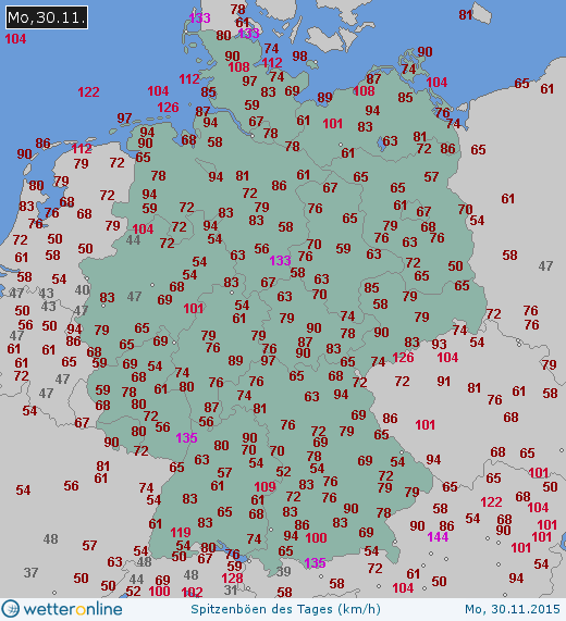
Montag, 30.11. – Am Montag bleibt es stark bewölkt, auch die Schauer werden nicht komplett abklingen. Am Abend kommt zudem ein neues Regengebiet nach Berlin. Die Temperaturen werden den ganzen Tag lang um 5 oder 6°C liegen. Der Wind bleibt tagsüber meist mäßig und wird aus Westen kommen. In der Früh gibt es noch einzelne STURMBÖEN, die aber bald abklingen werden. Erst am Abend muss man dann wieder auf STÜRMISCHE BÖEN vorbereitet sein.

ZUSAMMENFASSUNG: Stark bewölkt mit Schauern, am Abend ein neues Regengebiet. 5 bis 6°C bei weiterhin mäßigem Wind und in der Früh noch STURMBÖEN, am Abend erneut STÜRMISCHE BÖEN.


WEITERE AUSSICHTEN:

Dienstag, 01.12. – Bedeckt, 4 bis 7°C

Mittwoch, 02.12. – Bedeckt, 6 bis 10°C

Donnerstag, 03.12. – Regnerisch, 7 bis 10°C

Freitag, 04.12. – Stark bewölkt, 3 bis 5°C

Samstag, 05.12. – Bedeckt, -1 bis 5°C

Sonntag, 06.12. – Wolkig, -1 bis 3°C

Montag, 07.12. – Bedeckt, -1 bis 3°C


————————————————–


Saturday, 28.11. – Passage of a front with SNOW and later rain. Afterwards mainly cloudy. -2 to 6°C, mainly light wind. From the afternoon on gusts around 50km/h.


Sunday, 29.11. – Rain, partially SLEET, later also in the form of showers and partially in THUNDERSTORMS. 1 to 8°C with STORMY GUSTS, in the evening STORM GUSTS around 85km/h.


Monday, 30.11. – Mainly cloudy with showers, in the evening new rain. 5 to 6°C and continuing moderate wind with STORM GUSTS in the morning, in the evening again STORMY GUSTS.


TREND:


Tuesday, 01.12. – Overcast, 4 to 7°C

Wednesday, 02.12. – Overcast, 6 to 10°C

Thursday, 03.12. – Rainy, 7 to 10°C

Friday, 04.12. – Mainly cloudy, 3 to 5°C

Saturday, 05.12. – Overcast, -1 to 5°C

Sunday, 06.12. – Cloudy, -1 to 3°C

Monday, 07.12. – Overcast, -1 to 3°C

2015.11.28 – ESC: Storm NILS II

Storm NILS II is currently moving towards Europe, and will cause storm gusts throughout northwestern Europe. Live data can be found at www.milk-weather.org

Below is the latest GFS analysis.

2015.11.28