Hier sind wir wieder mit einer Winterwettervorhersage für Deutschland und Österreich. Die winterlichen Temperaturen sind schon angekommen, besonders in der Osthälfte Deutschlands und in Österreich, wo die Temperaturen zum teil derzeit unter -11°C liegen.
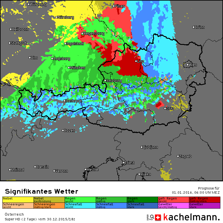
Heute zieht von Westen her eine Wetterfront durch das vorhersagegebiet, und besonders wenn die Niederschläge auf die kalte Luftmasse im Osten und Süden treffen, könnten sich durchaus interessante und gefährliche Situationen entwickeln. In der Früh liegt in Süddeutschland noch verbreitet eine gefrierende Nebeldecke. Ab dem späteren Vormittag ist lokal an der Vorderseite der Front mit EISREGEN zu rechnen. Zu diesem Zeitpunkt wird der EISREGEN hauptsächlich für Thüringen und Bayern vorhergesagt. Im Laufe des Nachmittags wird es weiterhin in beiden Bundesländern die Gefahr vor EISREGEN geben, besonders in Bayern, wo derzeit ein recht großes, zusammenhängendes Eisregengebiet berechnet wird. Der EISREGEN wird sich auch am Abend weiter ausbreiten. Unten ist die vorhersage des “Schweizer Modells” von Kachelmannwetter für heute, 18:00 MEZ. Rot = Eisregen.
Am Abend muss später auch in der Osthälfte von Mecklemburg-Vorpommern sowie im Nördlichen Brandenburg mit EISREGEN gerechnet werden. Auch in Bayern, besonders in Richtung Tschechien, sollte es weiterhin Eis regnen. Außerdem muss am Abend auch in Sachsen lokal mit EISREGEN gerechnet werden. In der Nacht kann der Eisregen besonders in den Mittelgebirgen in Schnee übergehen.
In Österreich bleibt es heute im Grßen und Ganzen zumindest Tagsüber ruhiger. Am frühen Nachmittag zieht leichter SCHNEEFALL durch Vorarlberg und Tirol. Allerdings wird am Abend der EISREGEN von Deutschland her auf Oberösterreich übergreifen, und vor allem nördlich der Alpen sowie am Alpenhauptkamm selber is mit lokalen SCHNEEFÄLLEN zu rechnen.
Die Temperaturen werden in Deutschland und Österreich heute meist auf positive Werte steigen, nur im Nordosten und Südosten von Österreich ist mit Dauerfrost zu rechnen.
Im weiteren Verlauf der Nacht wird der EISREGENin Deutschland immer weiter nach Osten ziehen, sich dabei aber auch nach Süden ausbreiten. In Bayern wird es weiterhin auch in der Mitte des Bundeslandes die Gefahr vor EISREGEN geben. SCHNEE ist lokal, vor allem in den Mittelgebirgen, auch mit dabei.
In Österreich wird sich der EISREGEN weiter duch Oberösterreich ausbreiten, im restlichen Bundesgebiet ist vorerst mit SCHNEE- und EISREGENSCHAUERN zu rechnen, die in Niederösterreich immer mehr in anhaltenden SCHNEEFALL übergehen werden. Die Situation wird recht chaotisch sein. Unten ist die Vorhersage des extrem hochaufgelösten Wettermodells von Kachelmannwetter:
Im weiteren Tagesverlauf verlagern sich die winterlichen Niederschläge in Österreich weiter nach Osten und schwächen sich dabei ab. In Deutschland ist schon ab dem Vormittag vorraussichtlich nicht mehr mit viel Schnee oder Eisregen zu rechnen. Am Abend kann es lokal in den östlichen Bundesländern noch etwas EISREGEN geben.
As the nameless severe storm that was the main issue yesterday is now moving away to the north, while still causing gusts around 160km/h on exposed Norwegian mountains, a new storm, named “ECKARD” is now approaching from the west. Even though the central pressure is still 973hPa, it is expeccted to drop to under 945hPa wihin the next few hours, and the wind speed is forecast to extremely pick up. Hence, there is a lot of wind to be expected in the British Isles. Below are the ESC Overview and the ESC Warnings and watches.
Dienstag, 29.12. – Heute bleibt es meist locker bewölkt, es wird viel Sonnenschein geben. Die Temperaturen liegen in der Früh zwischen 3 und 5°C, und werden tagsüber Höchstwerte um 6°C erreichen. Der Wind ist heute meist leicht, teils auch mäßig und kommt aus östlichen Richtungen.
ZUSAMMENFASSUNG: Locker bewölkt bei 3 bis 6°C und meist leichtem Wind
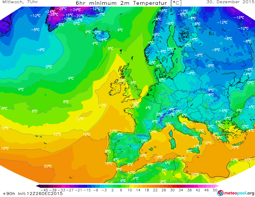
Mittwoch, 30.12. – Morgen sollte es die meiste Zeit lang sonnig sein, nur in der Früh kann es noch einzelne Wölkchen geben. Trotzdem werden die Temperaturen nur noch zwischen 0 und 2°C liegen. Der Wind wird wieder meist leicht sein, und aus südöstlichen Richtungen kommen.
ZUSAMMENFASSUNG: Sonnig bei 0 bis 2°C und leichtem Wind.
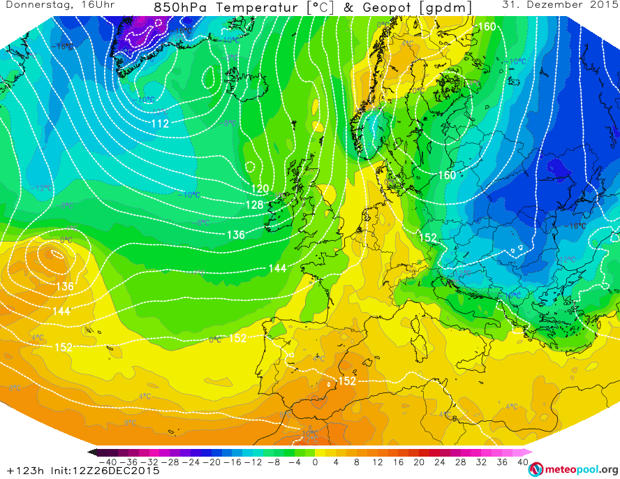
Donnerstag, 31.12. – Pünktlich zum letzten Tag des Jahres 2015 halten von Westen her neue Wolken Einzug, die sich im Laufe des Tages verdichten werden. Nach Sonnenuntergang ist dann schließlich mit verbreitetem EISREGEN, der auch recht stark sein kann und über mehrere Stunden anhalten wird, zu rechnen. Die Temperaturen werden in der Früh bei -1°C liegen, tagsüber auf bis zu 2°C ansteigen. Der Wind wird meist leicht sein und im Laufe der Zeit weiter nach Süden drehen.
ZUSAMMENFASSUNG: Zunehmende Bewölkung, am Abend EISREGEN. -1 bis +2°C und leichter Wind.
SILVESTERNACHT: In der Silvesternacht wird die meiste Zeit lang, nach jetzigem Stand der Vorhersagen, EISREGEN fallen. Im neuen Jahr wird der Niederschlag dann irgendwann aufhören, es wird aber weiterhin Bedeckt bleiben. Die Temperaturen werden in der Nacht auf -1°C absinken. Der Wind wird nur leicht sein.
WEITERE AUSSICHTEN:
Freitag, 01.01. – Zunehmend Wolkig, -1 bis +1°C
Samstag, 02.01. – Wolkig, -5 bis -3°C
Sonntag, 03.01. – Wolkig, -8 bis -5°C
Montag, 04.01. – Heiter, -8 bis -4°C
Dienstag, 05.01. – Heiter, -6 bis -4°C
Mittwoch, 06.01. – Heiter, -8 bis -6°C
Donnerstag, 07.01. – Wolkig, -12 bis -4°C
#################ENGLISH################
Tuesday, 29.12. – Few clouds at 3 to 6°C and mainly light wind.
Wednesday, 30.12. – Sunny at 0 to 2°C and light wind.
Thursday, 31.12. – Increasingly cloudy, in the evening FREEZING RAIN. -1 to +2°C and light wind.
NEW YEARS EVE: According to current predictions, most of the time there will be FREEZING RAIN. In 2016, however, the precipitation should eventually end, but it will stay overcast. The temperatures will drop to -1°C in the night. The wind will only be light.
There is only one storm system within the ESC map currently, with a central pressure of 971hPa and gusts reaching up to 120km/h in the UK. However, a new storm system is forecast to come accross the Atlantic today, and bring a lot more wind – it will be in tomorrows ESC overview. For now, below are the ESC overview as well as the warnings and watches. Stay safe!
In diesem Post wollen wir uns die weitere entwicklung des Winters in den kommenden Wochen anschauen. Dazu werden wir das GFS-Modell des amerikanischen Wetterdienstes verwenden, sowie auch das “HD” modell von Kachelmannwetter. Diese Modelle müssen nicht unbedingt richtig sein, und es gibt noch immer Widersprüche zwischen den unterschiedlichen Vorhersagen.
Kommende Nacht bleiben die Temperaturen jedenfalls in Deutschland fast überall noch über dem Gefrierpunkt, die ausnahmen sind dabei höhere Lagen.In der Nacht wird sich wahrscheinlich verbreitet Nebel bilden, aus dem bei Temperaturen unter dem Gefrierpunkt auch sehr leichter Schneefall kommen kann, besonders im Nordosten von Österreich.
Etwas kühler wird es in der Nacht danach, dann gibt es im Süden Deutschlands auch recht verbreitet Temperaturen um 0°C. In Österreich liegen die Temperaturen auch meist um den Grefrierpunkt, in den Alpen auch etwas drunter. Am Wärmsten bleibt es im Flachland, vor allem im Nordosten. Im Süden Deutschlands kann es in der Früh und am Vormittag lokal gefrierenden Nebel geben. Am Nachmittag wird der Nebel im Raum München mit leichtem Schneefall reißen, der Schnee sollte aber nicht liegen bleiben. In Österreich gibt es in der Früh besonders in Oberösterreich lokal gefrierenden Nebel, ganz im Südosten Österreichs kann es auch sehr leichten Schneefall geben. Späte muss im südöstlichen Niederösterreich und im Nordosten der Steiermark lokal mit gefrierendem Regen gerechnet werden. Nach Sonnenuntergang kann es lokal in manchen Teilen Österreichs, besonders dem äußersten Norden und in der Steiermark, wieder etwas schneien, schneeregnen, graupeln oder eisregnen. Eine Schneedecke ist trotzdem nirgendwo zu erwarten.
Noch kühler wird es in der Nacht zum Mittwoch. Die Temperaturen werden in der Osthälfte Deutschlands fast überall um oder unter 0°C liegen, in Österreich wird es nur sehr lokal am Neusiedler See, Bodensee und in der Südsteiermark wärmer bleiben. Im Süden Deutschlands gibt es am Mittwoch besonders in der Früh und am Vormittag leichten Schneefall. Auch in Österreich werden die Niederschläge mit der Zeit in der Nacht immer weiter in Schnee übergehen und auch tagsüber sollte es Schneefall bleiben. Schnee wird vor allem in der Steiermark fallen.
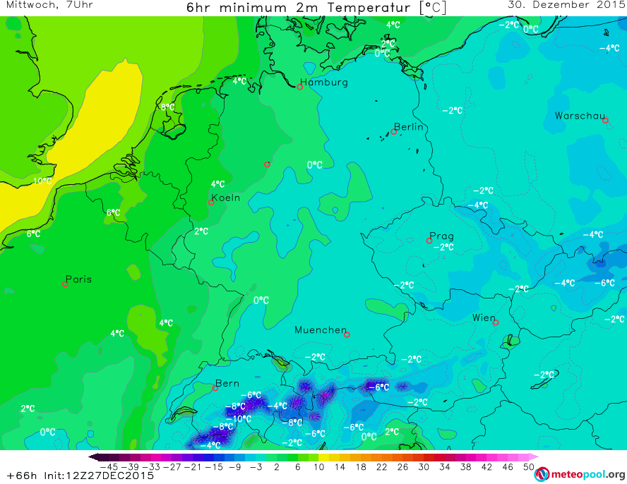
Minimumtemperaturen in der zweiten Nachthälfte der Nact auf Mittwoch. GFS.
In der Nacht auf Donnerstag breitet sich die kalte Luft in Deutschland weiter nach Westen aus, in Österreich wird es spürbar kälter sein als in den vorangegangenen Nächten. Am Donnerstag zieht eine Front von Westen in das Vorhersagegebiet. Im Relativ milden Westen Deutschlands wird der Niederschlag meist noch als Regen fallen, sobald die Front aber auf die kältere Luftmasse trifft ist mit Eisregen und nachfolgend Schneefall zu rechnen. Es ist zu erwarten, dass es in einigen Teilen Deutschlands zu erheblichen Verkehrsbehinderungen kommen wird. Auch in Westen und Nordwesten Österreichs ist ab dem Nachmittag mit teils starkem Schneefall zu rechnen. Der Schnee kann dabei teils auch im Flachland liegen bleiben, zum beipsiel ist derzeit in Salzburg eine geschlossene Schneedecke von ca. 3cm prognostiziert. Der Schnee hat aber in der Nacht die größte Wahrscheinlichkeit liegen zu bleiben. Auch in Deutschland muss ab dem Nachmittag zunehend damit gerechnet werden, dass der Schnee liegen bleibt.
Minimumtemperaturen in der Nacht auf Donnerstag. GFS.
In der Nacht auf Freitag wird es zwar im Westen Deutschlands wieder etwas wärmer, dafür wird der Winter, dort wo er jetzt schon entgültig angekommen ist, festigen, und besonders in Österreich werden die Temperaturen weiter sinken. Am ersten Tag des neuen Jahres wird es in einem Streifen durch die Mitte Deutschlands weiterhin, aber mit abnehmender Stärke, schneien. Auch in Österreich muss noch mit teils starkem Schneefall gerechnet werden, der sich am Freitag auch weiter nach Süden und Osten ausbreiten kann.
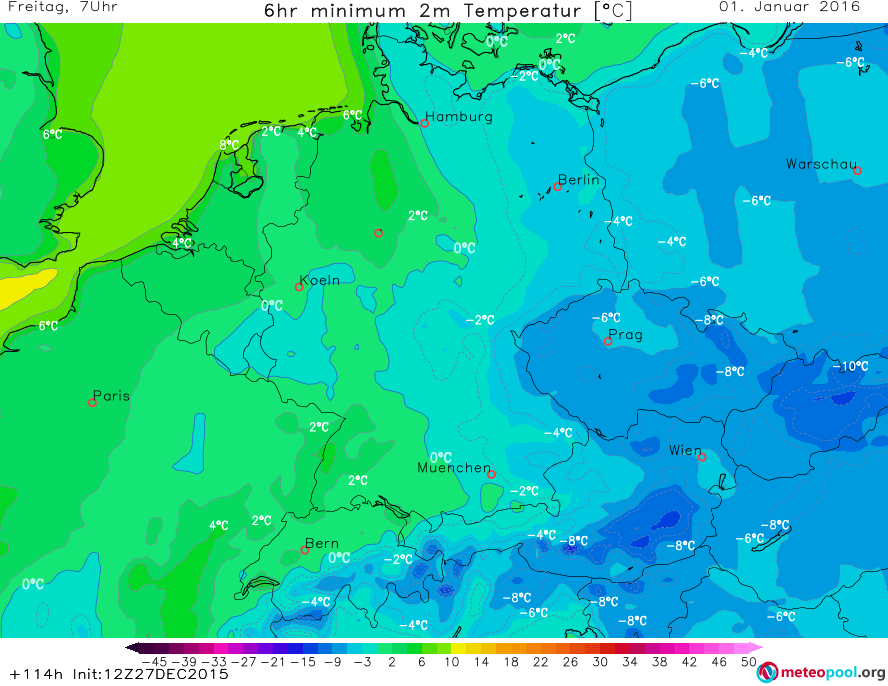
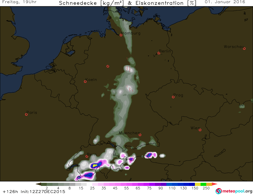
Minimumtemperaturen in der Silvesternacht. GFS.Schneedecke am Abend des Neujahrstages. GFS.
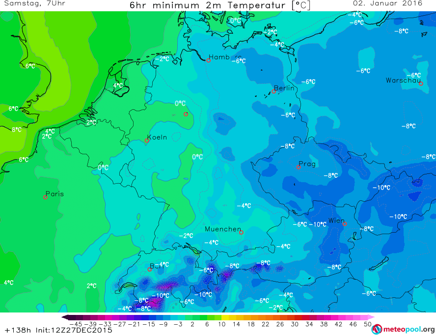
In der Nacht zum Samstag wird der Winter sich wieder weiter nach Westen ausbreiten, die Temperaturen werden im Osten Deutschlands und in Österreich noch deutlich sinken. Im Nordosten Österreichs werden die Temperaturen teils auf unter -10°C sinken. Am Samstag ist außer in der Mitte Deutschlands mit keinem Neuschnee zu rechnen. Dafür wird die Schneedecke an anderen Orten leicht tauen. Im Osten und Norden Deutschlands sowie auch in den meisten Teilen Österreichs ist mit Dauerfrost (d.h. Maximumtemperaturen unter 0°C) zu rechnen.
Minimumtemperaturen in der Nacht zum Samstag. GFS.
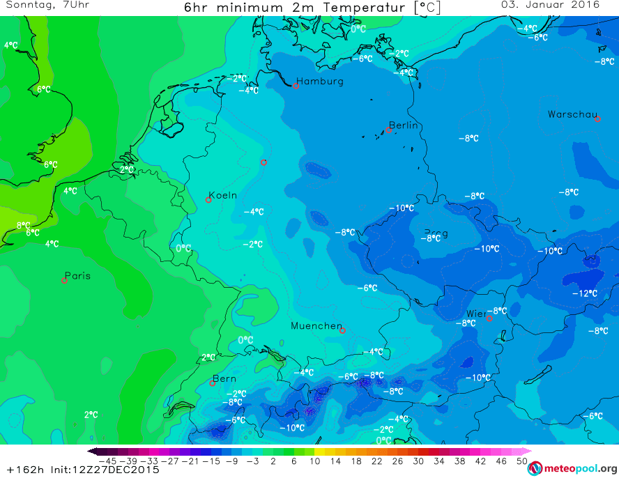
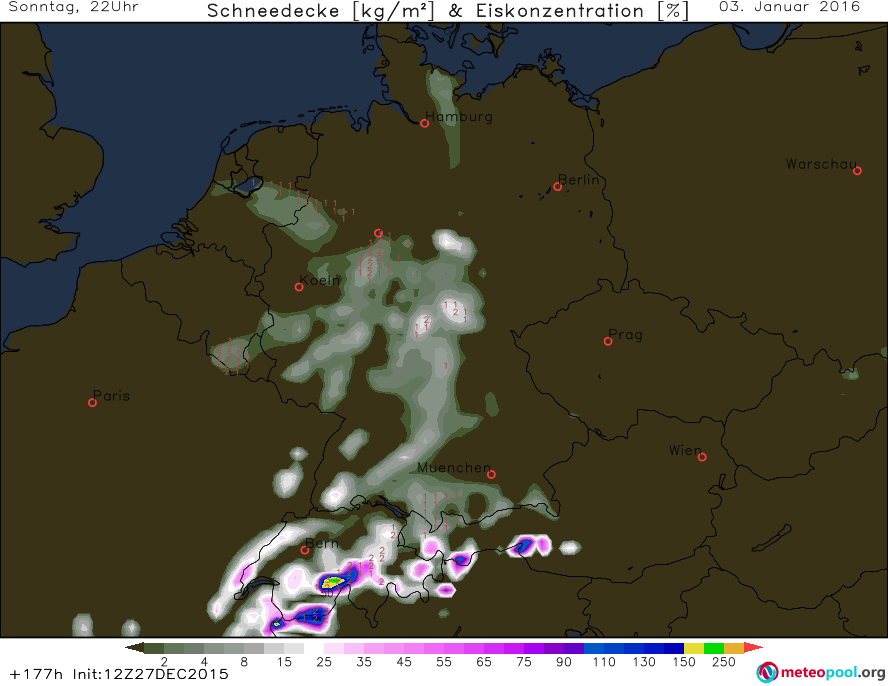
In der Nacht auf Sonntag werden die Temperaturen noch weiter absinken, auch im Westen Deutschlands ist jetzt fast überall mit Frost zu rechnen. Außerdem zieht von Südwesten ein neues Niederschlagsgebiet nach Deutschland, und bringt Schnee, teils auch Eisregen mit. Ab dem Nachmittag is im Westen und Nordwesten von Österreich auch wieder mit Schnee zu rechnen. Im Nordosten Deutschlands sowie auch in der Osthälfte Österreichs ist wieder vrebreitet mit Dauerfrost zu rechnen.
Minimumtemperaturen in der Nacht zum 3. Jänner. GFS.
Schneedecke am Abend des 3. Jänners. GFS.
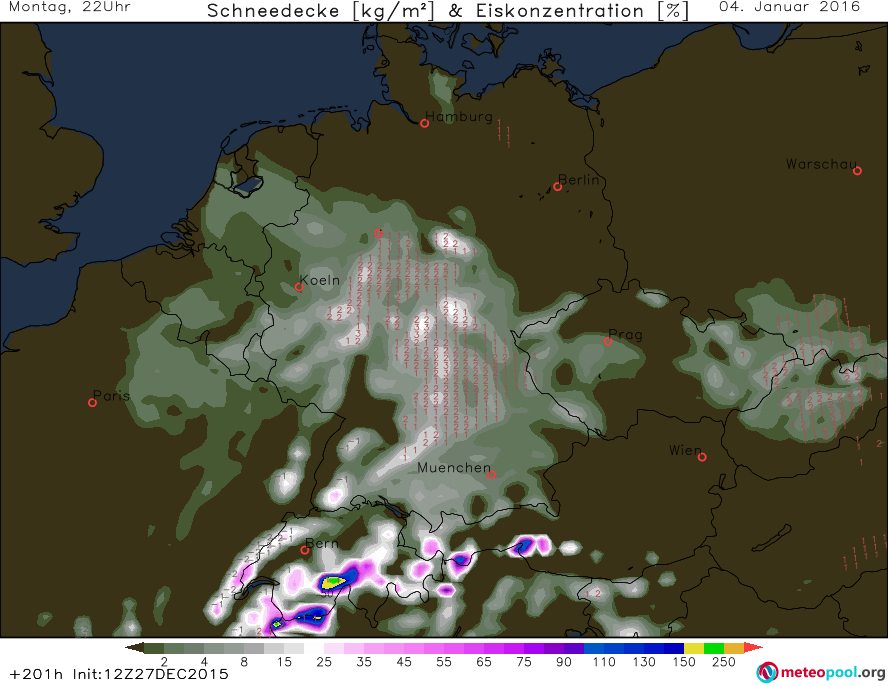
In der Nacht zum 4. Jänner wird es wieder etwas wärmer, vor allem im Westen Deutschlands ist nicht mal mehr mit Frost zu rechnen. Ansonsten ist zwar noch Frost zu erwarten, aber nicht mehr so streng wie in den Nächten davor. Dauerfrost ist trotzdem noch im Nordosten Deutschlands und im Osten Österreichs zu erwarten. Schnee ist auch am 4. fast überall im Vorhersagegebiet zu erwarten.
ESC Is currently tracking three storms in Europe and the northern atlantic. Storm DANIEL is now moving twoards the east, and is currently affecting the coast of Germany as well as Denmark. At the same time, there is a fairly powerful low pressure system near Greenland, with peak gusts close to 130km/h being reported from Greenland. Locally, higher wind speeds can be expected. Currently most concerning is the severe storm located to the southwest of Ireland, as it is expected to continue moving towards the northeast and hence affect the British Isles (and later the coast of Norway). Warnings and watches have been issued.
Even though there are still big differences between the ways that the forecast models predict the situation, most of them do say that the temperatures in Europe will drop, at least for a short time. We will look at ONLY THE GFS and UK Met Office models in this forecast. Please note that GFS (and UK Met Office) isn’t always correct and other forecast models may be better.
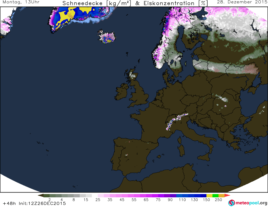
Tomorrow the overall situation will stay very similar to today. There will be a cold air mass over scandinavia, which will advance towards the southeast, into russia. Other than that, it will stay fairly mild even though to the north of the chain of low pressure areas and their associated fronts it will be a little cooler. At the back of a powerful low near Greenland, cold air will be advected towards the southeast, however it will not affect Europe. The minimum temperatures will stay above zero in most of Europe except Scandinavia, Russia and the mountains. A snow cover will continue to exist in much of Scandinavia and Russia as well as the highest peaks of the Alps and in the Scottish highlands.
GFS minimum temperatures for the comning night, 00 to 06UTC.
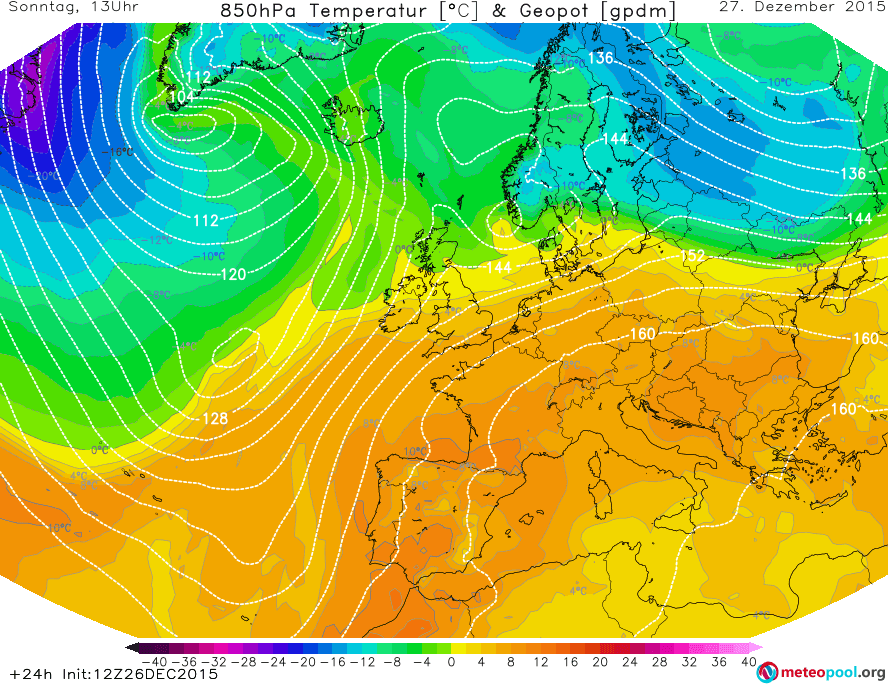
850hPa temperatures (air masses) for tomorrow, 12UTC. GFS.
12UTC ground forecast by UK Met Office
Snow for tomorrow, 12UTC. GFS.
The weather over most parts of Europe will remain warm also on Monday. The powerful low pressure area near Greenland will continue to deepen and reach a central pressure of 951hPa on Monday, 12UTC. It’s frontal systems will span all the way from Greenland/Iceland over the British Isles and the Iberian peninsula. Below is the UK Met Office’s prediction of the SSL pressure and location of the fronts.
Monday 12UTC ground analysis, UK Met Office
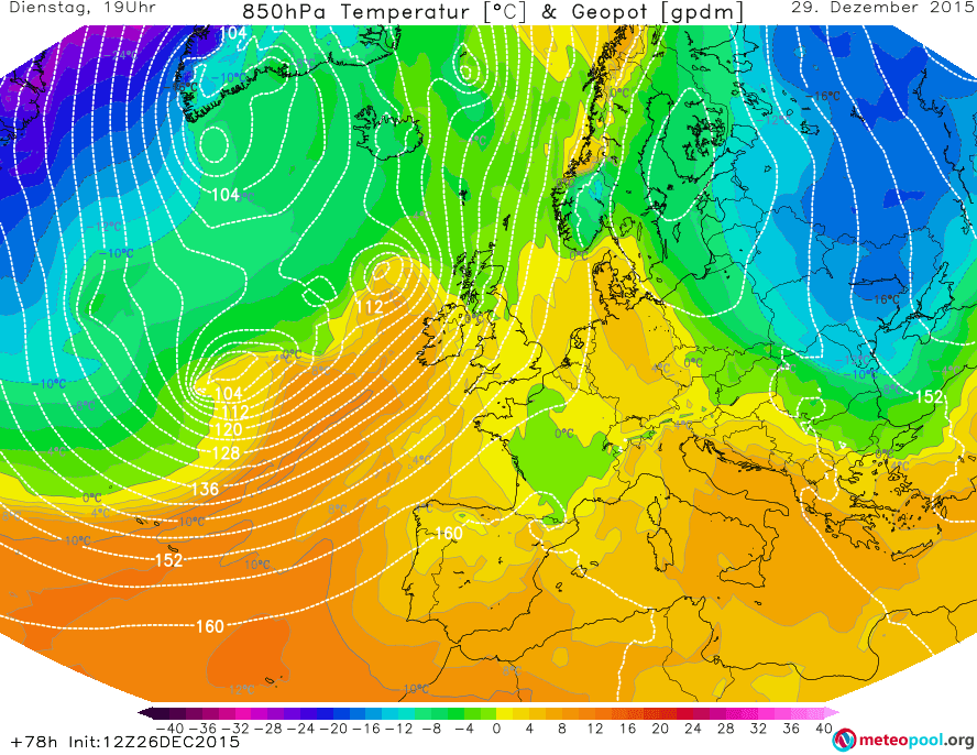
In front of the low pressure area and with the help of the high (1033hPa) located over Italy, warm air will be advected from the south and/or southwest up to Iceland and possibly even Greenland. Cool air continues to linger of Russia and especially northeastern Scandinavia, and will slowly start advancing towards the South or southsouthwest. Below is the 850hPa temperature and geopotential height map by GFS for Monday, 12UTC.
Monday, 12UTC 850hPa temp. GFS.
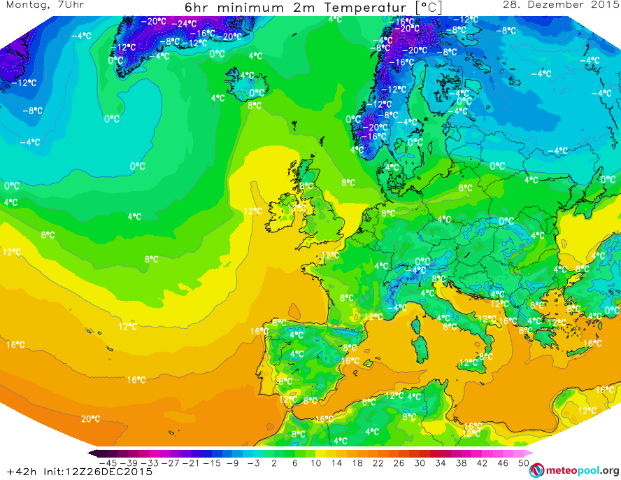
The minimum temperatures will, again, be mainly above zero, except for the mountains, Scandinavia, Russia and the Baltic states.
Monday, 00 to 06UTC minimum temperatures, GFS.
Snow will be on the groundin Scandinavia and Russia as well as along the front that the cold air mass, advecting to the southwest, causes. Other than that, snow is only found on the highest peaks of the Alps, southeast Euope and the Scottish highlands.
Snow on Monday, 12UTC. GFS forecast.
On Tuesday, the high pressure area located over northeastern Scandinavia will further strenghten, and at 12UTC a central pressure of 1047hPa is forecast by the UK Met Office. The frontal system, in front of which a large warm air mass was advected towards the north on Monday, will weaken and the flow of warm air will do so to. Behind the front(s), a cooler air mass will move in, however a general southwesterly flow will continue to exist, thanks to new low pressure areas moving towards Europe over the Atlantic. The front caused by the cold air coming from Scandinavia/Russia will continue to move towards the SW (or so). UK Met Office predicts it to be located as far west as eastern Germany, while GFS predicts the cold air mass to still be quite a bit further east.
Tuesday, 12UTC ground forecast by UK Met Office.
Warm air will continue to dominate in western Europe, and even warmer air masses will be advected by the low(s) over the Atlantic. The cold air over eastern Europe will continue to spread to the south and southwest, and at the leading edge of teh advance there will be a cold front (see the map above). GFS does not calculate the cold air mass to reach Germany yet, as the UK Met Office does.
While the minimum temperatures over western Europe will still stay largely the same, those over eastern Europe will, in many places, be lower than the days before.
Minimum temperature Tuesday, 00 to 06UTC. GFS.
The cold front at the leading edge of the cold air mass coming from Russia is not expected to produce a lot of precipitation anymore on Tuesday, and especially not snow that would stay on the ground. The areas in which snow will be covering the ground will stay largely the same as on Monday.
On Wednesday, the differences between the predictions by the GFS and the UK Met Office will be even bigger than they were on Tuesday. UK Met Office predicts a very impressive low over Iceland, with a 12UTC central pressure of only 939hPa. In front of the frontal system of this low-pressure area, warm air will be advected from the south, over far western Europe and the British isles and into Scandinavia, while just to the east, over most of Europe, the cold Scandinavian/Russian air mass will dominate, with the leading fronts of the BeNeLux states and Germany, along the coast of the Balkans, to the north of Greece and along the black sea. According to the UK Met Office, everything to the east of Germany will be affected by the cold air mass from the northeast.
UK Met Office ground forecast for Wednesday, 12UTC
GFS, on the other hand, also predicts the advection of warm air far to the north in front of a low somewhere around Iceland. However, in GFS, the cold air mass from the east will still reamain further in the east and mainly spread to the south and southwest, not so much to the west. Most of central Europe will still largely be affected by a warm air mass.
GFS: 850hPa for Wednesday, 12UTC.
Nonetheless, the temperatures over central Europe will be lower than on the previous days, and the minimum temperatures will, in many places, drop below 0°C. The temperatures in eastern Europe will continue to decrease compared to the previous days.
Minimum temperatures for 00 to 06UTC on Wednesday, GFS.
The snow will stay largely where it was in the previous days, but a little bit of new snow can fall in the mountains of Romania.
For Thursday, GFS expects the cold air mass to move further to the southwest, all the way to the Adriatic sea. At the same time, a cooler air mass will move towards the UK and Ireland from the northwest. Meanwhile in northern Scandinavia, “warm” air will take over.
ESC is currently tracking only one single storm on the ESC overview map: Severe storm DANIEL. The wind field of Daniel is fairly strange, thanks to high pressure to the north and south of central Europe. Therefore the peak gust of DANIEL is currently 130km/h, and was registered in Poland.
Othe than DANIEL, there are a couple of other areas throughout Europe in which there is currently strong wind, but that are not directly related to a single storm or the storm hasn’t formed yet – warnings and watches have been issued for these areas. See below for the ESC maps!
A new storm has now entered the stage, and is currently located to the W of the British Isles. At the same time, the storms BJARNI and AREND continue to exist, and BJARNI has even intensified – reaching peak gusts of over 190km/h in Norway, and with a central pressure of now only 954hPa. Storm AREND has stayed just as powerful as yesterday, however the airpressure has slightly increased.
Windy weather is to be expected in (northern) Europe in the coming days, currently thanks to the severe storm BJARNI, which has already caused intense gusts over 170km/h in the UK. Warnings have been issued for large parts of Europe. Please note that the wind is usually strongest at the coasts, on mountains, open fields and other exposed places and that a warning does not mean that this intensity is expected everywhere in the country.