2018.07.21 – Feeling the Heat in Scandinavia

Temperatures have well exceeded 30°C in much of Scandinavia for the past several days, including as far north as the Arctic circle. Below is a map of the maximum temperatures recorded on the 18th of July, though past days have all brought similarly intense heat to Scandinavian countries:

Image from www.kachelmannwetter.com


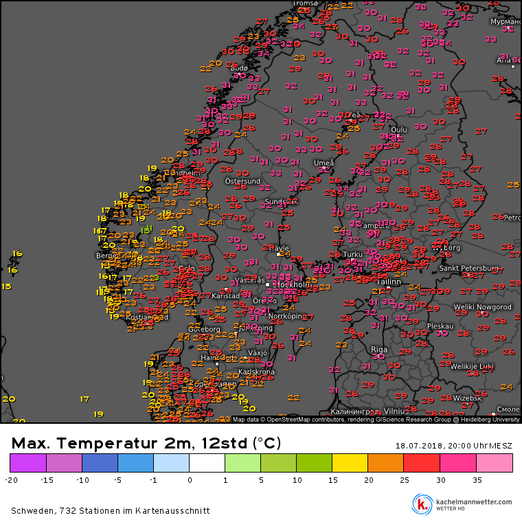
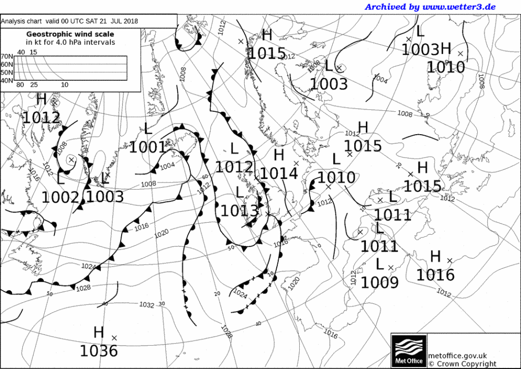
The reason for these unusually warm temperatures is a high-pressure ridge which is currently situated over northeastern Europe, including mainly the Scandinavian countries of Sweden and Finland, the north of Norway and the northwest of Russia, and bringing temperatures as high as 33.5°C in Bardufoss (69° N in Norway, registered 18th of July).

Image from www.wetter3.de


And for now, the hot weather is expected to persist. The heat, and especially the dryness (which is a problem in much of Europe currently) are posing some serious challenges, with numerous wildfires having broken out in Sweden, and at least in the upcoming days, little relief looks to be on its way.


2018.06.10 – Early Warning regarding THUNDERSTORMS for Berlin and Brandenburg

Issued 2018.06.10 at 12:00 CEST

www.milk-weather.org
 
There is a significantly increased potential for severe thunderstorms this afternoon.
According to the latest forecast model runs, thunderstorms will be moving through Berlin and Brandenburg starting in the mid-afternoon and continuing into the early evening, before thunderstorm activity decreases through the night.
These thunderstorms will have the potential to become severe.
The main concern today, due to the relatively large quantities of water in the air and the comparatively slow motion of the thunderstorms, will be excessive rainfall which may easily reach up to 25 liters per square meter in a time span of about an hour. Even extremely high rainfall rates exceeding 40 liters per square meter in short amounts of time are not to be ruled out. Further, and especially if the thunderstorms organize into a line, storm gusts of 55 to 70km/h are to be expected, with possible peaks reaching higher values. There is also an increased potential for hail, and if it does occur, it may have diameters of up to 3cm.
Due to the above potential severe weather events which may accompany the thunderstorms, as well as the always present risk posed by lightning, it is best to remain indoors during a thunderstorm.
Flash flooding can occur, causing serious delays in transportation and potential damage to property. Especially underpasses should be avoided, as quickly rising water levels can easily become life threatening. Small rivers may spring their banks.
Stay informed about the current and upcoming weather situation. Remain indoors during thunderstorms; if not absolutely necessary, do not drive during a storm.
Do not put yourself into any unnecessary danger.
This is solely a preliminary assessment of an upcoming potential severe weather situation; it is meant for guidance only and no guarantees are given.

2018.06.01 – Early Warning regarding THUNDERSTORMS for Berlin & Brandenburg

Issued 2018.06.01 at 08:20 CEST

www.milk-weather.org
 
Thanks to increasing heat and humidity, as well as an increased lifting factor ahead of a front approaching from the west, the atmosphere is layered in a very unstable way right from the morning on today. This will give rise to thunderstorms over the course of the day, many of which will have the potential for becoming severe. Showers and thunderstorms have started to spring up early this morning already, evidencing the labile layering of the atmosphere and potential for thunderstorms.
As mentioned above, due to the high potential energy, thunderstorms generally have the potential to become severe today.
Due to the generally very slow motion of the thunderstorms, the risk of flooding is especially pronounced today; amounts of up to 60 liters of rain per square meter in short time spans can lead to serious delays in transportation as well as flash flooding, especially in low-lying areas and near smaller rivers.
Further, the potential for hail with diameters of up to 3cm is given. If hail falls, it may fall with such an intensity that it forms a closed cover. The hail may also smash car windows and cause damage to roofs & vegetation, etc. If large hail starts falling while you are on the road, stop driving. Windows of parking cars can be protected using blankets.
Storm gusts of up to 80km/h can also not be ruled out, especially at the leading edge and in the precipitation of the thunderstorms.
Stay informed about the current and upcoming weather situation. Remain indoors during thunderstorms; if not absolutely necessary, do not drive during a storm.
Do not put yourself into any unnecessary danger.
This is solely a preliminary assessment of an upcoming potential severe weather situation; it is meant for guidance only and no guarantees are given.

2018.05.30 – Early warning regarding THUNDERSTORMS in Berlin & Brandenburg

Issued 2018.05.30 at 10:30 CEST

After having had several hours of sunshine providing plenty of energy (and temperatures of up to 33°C), convective clouds will start forming in the afternoon, which will quickly grow into rain showers and thunderstorms. These are expected to stay isolated (i.e. individual clouds) and therefore it is impossible to say exactly when and where a thunderstorms will form and strike.
Due to the high available potential energy, thunderstorms have the potential to become severe.
The main risks to be expected from today’s thunderstorms are excessive precipitation of up to 60 liters per square meter within short time, as well as large hail of up to 4cm in diameter.
Excessive precipitation can lead to significant delays in traffic and may lead to flash flooding. Large hail can result in property damage, especially to cars and roofs. Prepare accordingly.
To a lesser extent, the potential for storm gusts of up to 100km/h is given as well.
Stay informed about the current and upcoming weather situation. Remain indoors during thunderstorms; if not absolutely necessary, do not drive during a storm.
Do not put yourself into any unnecessary danger.
This is solely a preliminary assessment of an upcoming potential severe weather situation; it is meant for guidance only and no guarantees are given.

2018.05.15 – Convective Forecast (Thunderstorm Forecast) for Germany and Central Europe (English Version)

Issued 2018.05.15 at 06:00 CEST

Wide parts of Germany and Central Europe present the right conditions for the formation of thunderstorms today. This is due to the unstable layering of the atmosphere which, in combination with the energy that the sun provides, will lead to the formation of local heat-induced thunderstorms in the afternoon.

Most of these thunderstorms will be rather narrowly confined, meaning that if one town is hit by a thunderstorm, the neighboring town may stay entirely dry.

The general direction the thunderstorms will move across Germany is from Northeast to Southwest.

The main risk stemming from today’s thunderstorms is strong rain of between 20 and 40 liters per square meter in short time (under an hour). Flash flooding can take place, which can result in traffic delays and property damage. Further, in and around thunderstorms, storm gusts of up to 70km/h are possible. Also small hail, which will in the most cases not exceed a diameter of 2cm, is not to be ruled out. Hail with more than 2 or 3cm in diameter, tornadoes, as well as strong, structured thunderstorms are unlikely under today’s conditions.

If possible, keep yourself informed about the current weather situation.

Below, you will find the “Convective Forecast” for Central Europe.

2018.05.15 – Gewitter-Vorhersage für Deutschland, Österreich und Mitteleuropa (Deutsche Ausgabe)

Ausgegeben 2018.05.15 um 06:00 MESZ

Über weiten Teilen Deutschlands und in weiten Teilen Mitteleuropas besteht heute das Potential für Gewitterbildung. Das liegt an der instabilen Schichtung der Atmosphäre, welche in Verbindung mit der zunehmend vorhandenen Energie der Sonne im Laufe des Nachmittags lokale Wärmegewitter entstehen lassen wird.

Die meisten dieser Gewitter werden lokal eng begrenzt bleiben, was bedeutet, dass während ein Ort ein Gewitter abbekommt, der Nachbarort davon möglicherweise nichts mitbekommt.

Die generelle Zugrichtung der Gewitter ist über Deutschland von Norosten nach Südwesten.

Die Hauptgefahr bei den heutigen Gewittern stellt Starkregen mit mengen von 20 bis 40 Litern pro Quadratmeter in kurzer Zeit her. Damit können Überflutungen inklusive Verkehrsbehinderungen und Sachbeschädigungen vorkommen. Weiters können in und nahe den Gewittern Sturmböen von bis zu 70km/h auftreten. Auch kleinkörniger Hagel, der meist unter 2cm im Durchmesser betragen wird, ist nicht auszuschließen. Hagel mit mehr als 2 oder 3cm Durchmesser, Tornados sowie kräftige, strukturierte Gewitter sind unter den heutigen Bedingungen äußerst unwahrscheinlich.

Halten Sie sich nach Möglichkeit über die aktuelle Wetterlage am Laufenden.

Unten finden Sie die heutige “Convective Forecast” – Schwergewittervorhersage für Mitteleuropa.

2018.04.04 – Thunderstorm Forecast for Germany, Central Europe: Storm gusts, especially in Brandenburg, Saxony, Saxony-Anhalt, Berlin (English Version)

Issued 2018.04.04 at 08:40 CET

As soon as spring has fully arrived in central Europe, the thunderstorm season is already setting off.

A cold front is moving eastwards across Germany today, ahead of which partly strong showers and thunderstorms will form. Currently (08:40 local time) there are already a number of strong showers to be found in the southwest of Germany. The showers and thunderstorms will move towards the northeast, and will have reached Brandenburg and Berlin by the evening. According to the latest predictions, the highest potential for strong and severe thunderstorms will be found in the afternoon and evening in Saxony, the southern half of Brandenburg and parts of Saxony-Anhalt.

Due to the current and prognosticated conditions in the atmosphere, the main risk stemming from these storms will be storm gusts and severe storm gusts between 70 and 110km/h (these can also occur along the cold front outside of thunderstorms!)
Further, in showers and thunderstorms high rates of precipitation of around 15 liters per square meter in an hour, and locally hail up to 3cm in diameter are to be expected.

If possible, keep up to date with the current weather situation.

Below, you will find the Convective Forecast / Thunderstorm Forecast for Central Europe:

2018.04.04 – Gewitter-Vorhersage für Deutschland, Mitteleuropa: Sturmböen & Unwetter, besonders in Brandenburg, Berlin, Sachsen, Sachsen-Anhalt

Ausgegeben 2018.04.04 um 08:40 MEZ

Kaum ist der Frühling so richtig in Mitteleuropa angekommen, da geht die Gewittersaison auch schon los.

Heute erreicht Deutschland von westen her eine Kaltfront, in deren Vorfeld sich teils kräftige Schauer und Gewitter entwickeln werden. Schon derzeit (08:40 Ortszeit) finden sich im Südwesten Deutschlands einige starke Regenschauer. Die Schauer und Gewitter werden sich im Tagesverlauf von Südwesten nach Nordosten verlagern, und bis zum Abend Brandenburg und auch Berlin erreicht haben.
Nach derzeitigem Stand der Vorhersagen besteht das größte Potential für kräftige Gewitter und Unwetter am Nachmittag und Abend in Sachsen, der Südhälfte Brandenburgs und teilen Sachsen-Anhalts.

Aufgrund der derzeitigen und prognostizierten Bedingungen in der Atmosphäre besteht die Hauptgefahr bei den heutigen Gewittern in Sturmböen und schweren Sturmböen zwischen 70 und 110km/h (diese können auch außerhalb von Gewittern entlang der Kaltfront auftreten!)
Außerdem muss in Schauern und Gewittern mit hohen Niederschlagsmengen von bis zu 15 Litern pro Quadratmeter in nur einer Stunde, sowie vereinzelt auch mit Hagel bis maximal 3cm in Durchmesser gerechnet werden.

Halten Sie sich nach Möglichkeit über die aktuelle Wetterlage am Laufenden.

Unten finden Sie die heutige “Convective Forecast” – Schwergewittervorhersage für Mitteleuropa.

2018.02.21 – ESC European Windstorm Update: Iceland to be Battered by a Severe Storm

The situation in Europe overall is rather calm currently, with one exception: Iceland should brace for the arrival of a very powerful storm within the next few hours. The storm system, currently packing wind speeds in excess of 130km/h and a central pressure of 987hPa, is expected to bring severe storm gusts to much of the island, and peak winds may exceed well beyond 200km/h in exposed locations. Warnings have been issued accordingly, see below.

Below are the ESC European Windstorm Overview, as well as the storm warnings and watches:


2018.02.12 – European Windstorm Update: Storm QUINN heading for the UK, Ireland and Iceland

There are currently two storms around Europe.

Storm PHILINE,  currently located over Denmark, is expected to more or less dissipate within the next 24 hours, and is currently only bringing storm gusts to a fairly small area consisting of Denmark and the far north of Germany.

However, from the northern Atlantic, a new storm is approaching: severe storm QUINN, currently located to the northwest of Ireland, is packing gusts exceeding 120km/h and has a central pressure of 988hPa. It is expected to strike Ireland and, a few hours later, the UK in the coming night, bringing wide-spread storm gusts and some severe storm gusts, especially in exposed locations. The storm will move northeast or north-northeast, and will also bring severe storm gusts to parts of Iceland by tomorrow morning. The French coast may be impacted between tomorrow morning and the early afternoon, as well. Storm warnings and watches have been issued accordingly. See below.

Below: ESC European Windstorm Overview, Warnings and Watches.