ESC is currently tracking a single storm in the north Atlantic, which may cause severe gusts up to 150km/h in Greenland, however will not affect Europe. In most of Europe, cold winter weather will presist and not much wind is expected.


Weather – Happening now, Online now.
ESC is currently tracking a single storm in the north Atlantic, which may cause severe gusts up to 150km/h in Greenland, however will not affect Europe. In most of Europe, cold winter weather will presist and not much wind is expected.
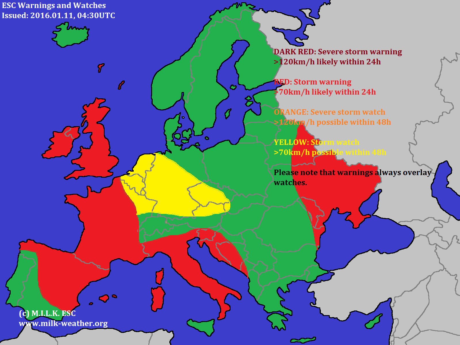
The situation is still fairly calm in Europe, currently there is not a single windstorm in the region. However, a low pressure area over the UK is forecast to cause stormgusts today and tomorrow, and hence warnings and watches have been issued for the region.


Donnerstag, 14.01. – Heute wird es meist stark bewölkt bleiben, am Nachmittag kann es einzelne Auflockerungen geben. In der Früh ist mit SCHNEE und auch Regen zu rechnen, nach Sonnenuntergang wird erneut SCHNEEFALL einsetzen. Es besteht GLÄTTEGEFAHR. Die Temperaturen reichen heute von 1 bis 3°C. Der Wind wird meist leicht sein und aus südlichen Richtungen kommen.
ZUSAMMENFASSUNG: Stark bewölkt, vereinzelt auch mit Regen oder SCHNEE. 1 bis 3°C und weiterhin GLÄTTEGEFAHR.
Freitag, 15.01. – Am Ende der Arbeitswoche ist es den ganzen Tag über stark bewölkt bis bedeckt und es wird SCHNEIEN. Die Temperaturen werden sich mit 0 bis 3°C auch nicht wesentlich ändern. Der leichte Wind wird mit der Zeit von Süden über Osten auf Norden drehen.
ZUSAMMENFASSUNG: SCHNEEFALL bei 0 bis 3°C.
Samstag, 16.01. – Auch am Samstag wird es meist bedeckt bleiben und weiterhin SCHNEIEN. Außerdem wird es mit -3 bis +1°C etwas kälter als an den Vortagen. Der Wind wird sehr leicht sein und aus nördlichen Richtungen kommen.
ZUSAMMENFASSUNG: SCHNEEFALL bei -3 bis +1°C.
WEITERE AUSSICHTEN:
Sonntag, 17.01. – Heiter, -4 bis -1°C
Montag, 18.01. – Wolkig, -8 bis -3°C
Dienstag, 19.01. – Wolkig, -9 bis -4°C
Mittwoch, 20.01. – Schneeschauer, -10 bis -4°C
Donnerstag, 21.01. – Bedeckt, -6 bis -1°C
Freitag, 22.01. – Wolkig, -7 bis -2°C
Samstag, 23.01. – Heiter, -7 bis -2°C
###################ENGLISH##########################
Thursday, 14.01. – Mainly cloudy with a possibility for SNOW or rain. 1 to 3°C and persisting risk of slippery roads and sidewalks.
Friday, 15.01. – SNOW at 0 to 3°C.
Saturday, 16.01. – SNOW at -3 to +1°C.
TREND:
Sunday, 17.01. – Fair, -4 to -1°C
Monday, 18.01. – Cloudy, -8 to -3°C
Tuesday, 19.01. – Cloudy, -9 to -4°C
Wednesday, 20.01. – Snow showers, -10 to -4°C
Thursday, 21.01. – Overcast, -6 to -1°C
Friday, 22.01. – Cloudy, -7 to -2°C
Saturday, 23.01. – Fair, -7 to -2°C
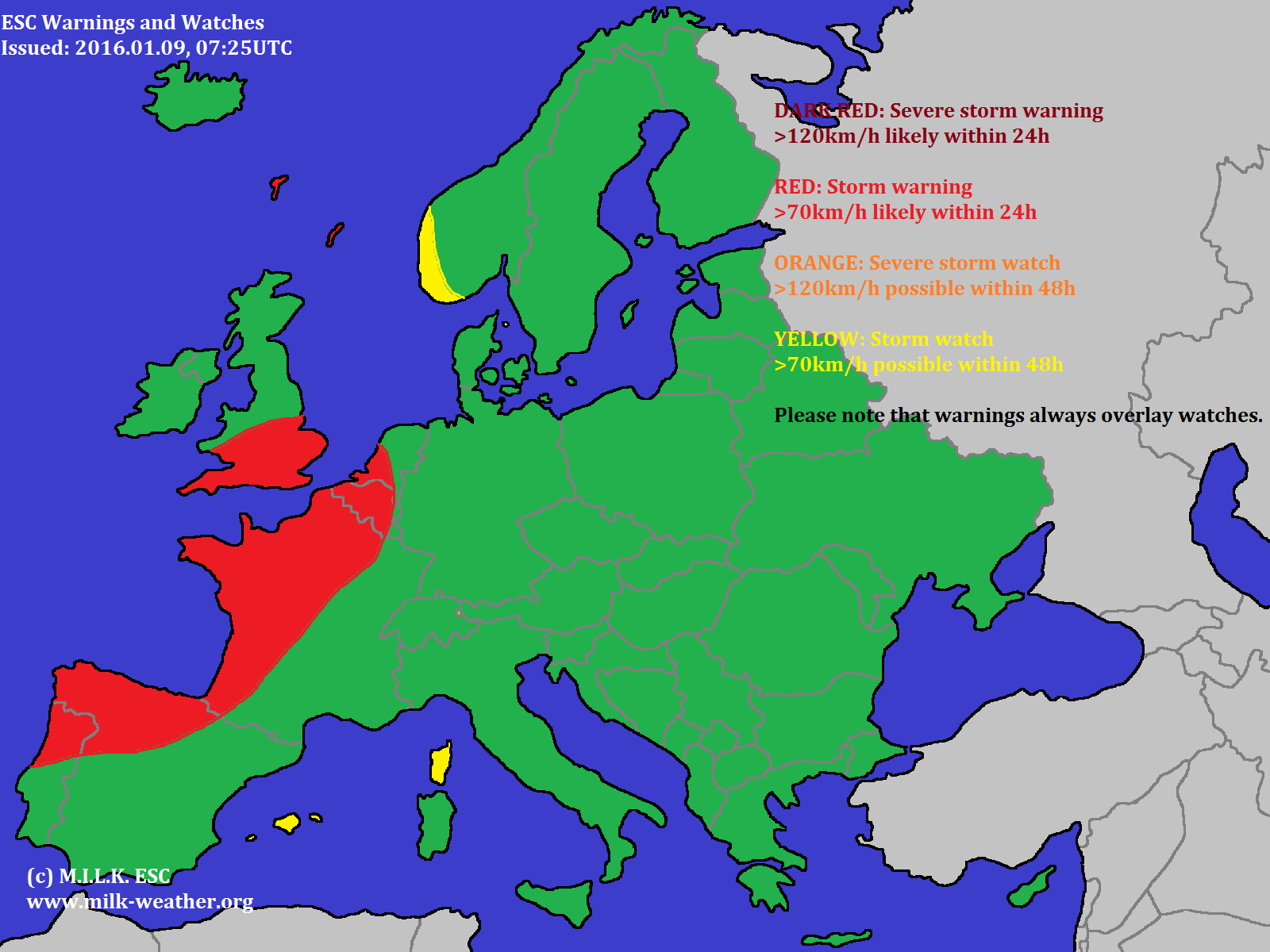
The only storm currently in the region that MILK ESC observes is CAROLINA, located over the UK. However, a second storm, which will be named DANEILLA, will split off and move over France and the Iberean peninsula and further into the mediterranean. Further it might cause storm gusts in far eastern Europe early tomorrow morning. A storm watch has been issued for central Europe due to the possibility of a small storm system forming and moving into Germany.

Storm BRITTA, currently located over the North Atlantic, is at this time the only storm in the region that ESC observes. It is not especially strong, however a few warnings and watches have been issued.

Below are places that should expect very intense conditions on the 9th of January (UTC). All data according to GFS forecasts.
HIGH WIND:
HIGH PRECIPITATION (24h):
GREAT SNOWFALL (24h):
HEAT:
COLD:
FREEZING RAIN:
SEVERE THUNDERSTORMS (SWEAT-Index):
HUMIDITY:
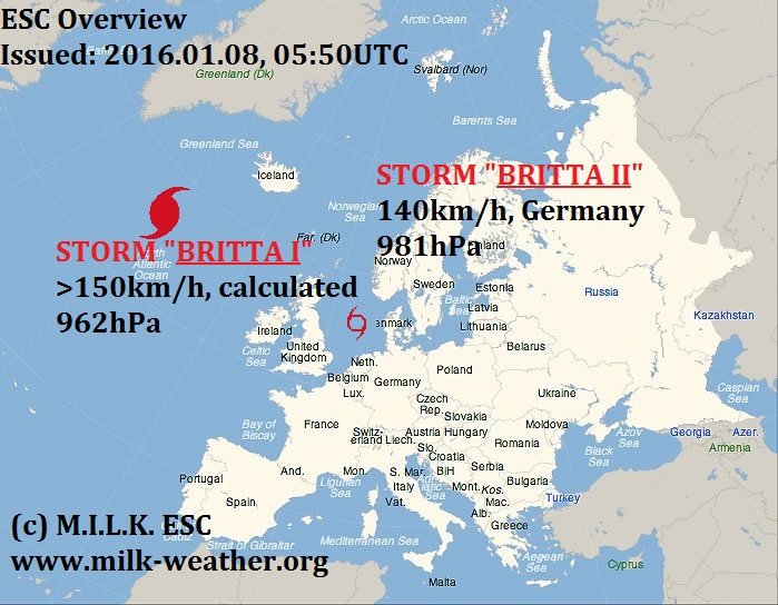
Two storms, named BRITTA I and BRITTA II are currently affecting Europe. Below is the ESC overview!
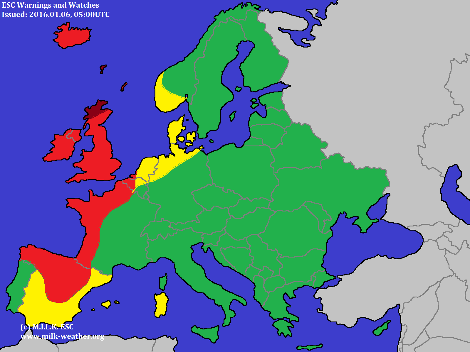
ESC is currently tracking a nameless system located to the south of Iceland. It is calculated to have peak gusts above 120km/h, and will affect the western coast of Europe as well as the British Isles. Warnings and watches have been issued.

Endlich fällt Schnee in Mitteleuropa, so zum Beispiel in der Österreichischen Stadt Graz, wo das Foto unten aufgenommen wurde. Aber Auch in Deutschland liegt derzeit zum Teil eine Schneedecke, besonders im Süden und entlang der Luftmassengrenze in der Mitte des landes.
Finally snow started to fall in Central Euope, for example in the Austrian city of Graz, where the photo below was taken. But also in Germany there is a regional snow cover, especially in the south and along front in the middle of the country.
https://milk-weather.org/gallery/_data/i/upload/2016/01/02/20160102233837-e2df22f2-me.jpg