Storm Ruzica, which brought storm gusts over 160km/h to central Europe yesterday, is now quickly weakening and is currently located over Scandinavia. However, a new storm is approaching from the West, named SUSANNA. Along the cold front of that storm, a new low is predicted to form over northern Italy. Below are the ESC Overview and the ESC Warnings and Watches maps.
2016.02.08 – BERLIN: WARNUNG vor STURMBÖEN / WARNING regarding STORM GUSTS
2016.02.08 – BERLIN: Wettervorhersage / Weather Forecast
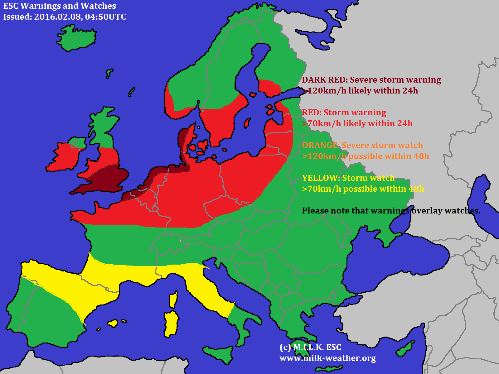
Montag, 08.02. – Heute ist es zwar anfangs noch teils freundlich doch ziehen noch am Vormittag Wolken von Westen auf und nachfolgend wird es Regen geben. Am Nachmittag wird es voraussichtlich noch stark bewölkt bleiben und ab und zu Regenschauer geben. Es bleibt heute recht mild bei Temperaturen zwischen 5 und 10°C. Der Wind wird meist mäßig, teils aber auch lebhaft sein und meist aus Süden kommen. Es muss außerdem mit SÜTMISCHEN- sowie vereinzelten STURMBÖEN um oder über 70km/h gerechnet werden.
ZUSAMMENFASSUNG: Meist stark bewölkt bei 5 bis 10°C. STURMBÖEN über 70km/h.
Dienstag, 09.02. – Morgen wird es anfangs wechselnd bewölkt sein, zum Abend hin aber wieder aus Südwesten zuziehen. Nach dem Sonnenuntergang ist dann wieder Regen zu erwarten. Mit 4 bis 8°C wird es zwar weiterhin mild sein, aber nicht mehr ganz so mild wie an den Vortagen. Der Wind wird leicht bis mäßig sein und aus südlichen Richtungen kommen. In der Früh und nach Sonnenuntergang sind trotzdem noch STÜRMISCHE BÖEN nahe 70km/h zu erwarten.
ZUSAMMENFASSUNG: Wechselnd bewölkt, am Abend regen. 4 bis 8°C und in der Früh sowie nach Sonnenuntergang STÜRMISCHE BÖEN nahe 70km/h.
Mittwoch, 10.02. – Am Mittwoch hält am Vormittag der Regen noch an, später wird es aber trockener und auch die Wolkendecke wird etwas aufreißen. Es wird noch etwas kühler, aber immer noch 3 bis 5°C warm. Der Wind wird leicht bis mäßig sein und aus Südwesten bis Westen kommen. Vor Sonnenaufgang kann es STURMBÖEN über 80km/h geben.
ZUSAMMENFASSUNG: Vormittags regnerisch, später freundlicher bei 3 bis 5°C. Vor Sonnenaufgang STURMBÖEN über 80km/h.
WEITERE AUSSICHTEN:
Donnerstag, 11.02. – Wolkig, 1 bis 4°C, STARKE BÖEN
Freitag, 12.02. – Heiter, 0 bis 4°C
Samstag, 13.02. – Bedeckt, -1 bis 4°C
Sonntag, 14.02. – Wolkig, 0 bis 8°C
Montag, 15.02. – Heiter, 0 bis 5°C
Dienstag, 16.02. – Wolkig, 0 bis 5°C
Mittwoch, 17.02. – Wolkig, 0 bis 8°C, STURMBÖEN
############################ENGLISH###########################
Monday, 08.02. – Mainly cloudy at 5 to 10°C. STORM GUSTS over 70km/h.
Tuesday, 09.02. – Partly cloudy, in the evening rain. 4 to 8°C and in the morning as well as after sunset STRONG GUSTS close to 70km/h.
Wednesday, 10.02. – In the morning rainy, later nicer weather at 3 to 5°C. In the early morning STORM GUSTS over 80km/h.
TREND:
Thursday, 11.02. – Cloudy, 1 to 4°C, STRONG GUSTS
Friday, 12.02. – Fair, 0 to 4°C
Saturday, 13.02. – Overcast, -1 to +4°C
Sunday, 14.02. – Cloudy, 0 to 8°C
Monday, 15.02. – Fair, 0 to 5°C
Tuesday, 16.02. – Cloudy, 0 to 5°C
Wednesday, 17.02. – Cloudy, 0 to 8°C, STORM GUSTS
2016.02.08 – ESC Overview/Warnings/Watches: Severe Storm RUZICA Making Landfall
Powerful and severe storm RUZICA is making landfall in Europe today, and, even though forecasts vary quite a bit, is expected to bring quite a bit of wind. In Germany, numerous carnival parades have been cancelled because of security risks. Below are the ESC Overview as well as the Warnings and Watches. Stay safe!
2016.02.07 – ESC: Storm Ruzica Picking up Speed in the N Atlantic
2016.02.04. – ESC: Storm PIA
2016.02.03. – ESC: The end of storm NORKYS
The remaints of storm NORKYS, which caused storm gusts quite a bit over 200km/h in the UK, are currently located over southern Scandinavia and will continue to move east. Within 12 hours, most of the damaging winds are expected to dissipate. Europe will generally be fairly calm today, with no new storm system taking over from the west. A new, and possibly very powerful storm system is expected to form over the North Atlantic tomorrow, and might cause severe storm gusts in Iceland.

2016.02.02. – Storm NORKYS moving East
Storm NORKYS, currently located to the North of the UK, will continue moving eastwards and is now also affecting central Europe with its wind field. Peak gusts in the UK reached up to 230km/h, showing the extreme force of this storm. The central pressure is currently 966hPa. Gusts have significantly started to pick up in central Europe, exceeding 150km/h on some mountains. NORKYS is the only Atlantic storm in the region, and therefore ESC decided to not publish the “traditional” overview.


2016.02.01 – Storm NORYKS will strike the British Isles with full force
The very powerful storm NORYKS, currently located near Iceland, will strike the British Isles today with storm gusts over 140km/h even in low areas and waves up to 14m at the coasts. Especially affected will be the North of the UK.


2016.01.29 – ESC Overview/Warnings/Watches: Chaos due to MARITA
Severe storm MARITA, currently located North of Ireland, is already causing storm gusts over 170km/h in the UK, and locally wind speeds can be even higher. In Ireland, there are currently 3,500 people without electricity thanks to MARITA. Warnings have been issued for big parts of Northern Europe. Please be careful in these regions! Below are the ESC overview as well as the Warnigns and Watches map.