2015.10 Monthly Report from station 10001 (Berlin Steglitz)

This is a station in the microclimate of the city Berlin. The MILK Weather Stations are not set up according to WMO standards, but rather MILK has it’s own standards regarding the setup of weather stations. Our goal is to gain knowledge about how the microclimate of different cities work, and to be able to give reliable and extreme local data to people. This cannot be achieved through the standard procedures, because the WMO standards for weather stations simply do not reflect the surrounding that the urban population has every single day. Therefore, the data might significantly vary from the “official” values. Especially the wind data – since the anemometer and wind vane are set up in a road facing SW to NE. However, the data is still reliable, but only valid on a very local scale.

———————————————————————————————
Averages\Extremes for the month of October 2015

———————————————————————————————
Average temperature     = 10.0°C
Average humidity        = 75%
Average dewpoint        = 5.7°C
Average barometer       = 1018.7 hPa
Average windspeed       = 0.5 km/h
Average gustspeed       = 0.8 km/h
Average direction       = 181° ( S )
Rainfall for month      = 46.2 mm
Rainfall for year       = 313.2 mm
Maximum rain per minute = 5.0 mm on day 14 at time 07:00
Maximum temperature     = 17.9°C on day 06 at time 16:37
Minimum temperature     = 0.3°C on day 12 at time 08:47
Maximum humidity        = 86% on day 20 at time 09:34
Minimum humidity        = 41% on day 10 at time 17:34
Maximum dewpoint        = 11.7°C on day 06 at time 16:37
Minimum dewpoint        = -4.0°C on day 11 at time 7:27
Maximum pressure        = 1032.2 hPa on day 31 at time 08:47
Minimum pressure        = 1007.9 hPa on day 06 at time 17:47
Maximum windspeed       = 7.4 kmh from 113°(ESE) on day 23 at time 13:06
Maximum gust speed      = 16.7 km/h from 203°(SSW) on day 23 at time 13:16
Maximum heat index      = 17.9°C on day 06 at time 16:37
Total windrun = 357.0km
———————————–
Daily rain totals
———————————–
00.7 mm  on day 7
12.6 mm  on day 8
09.9 mm  on day 14
02.8 mm  on day 15
10.5 mm  on day 16
06.3 mm  on day 17
06.3 mm  on day 19
00.7 mm  on day 22

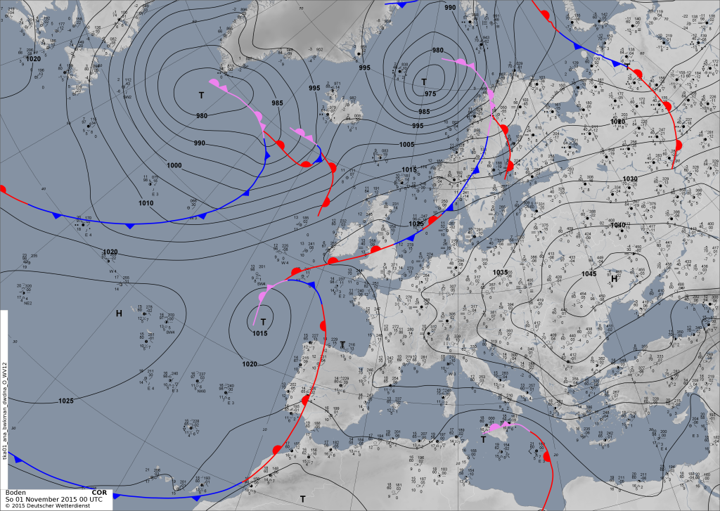
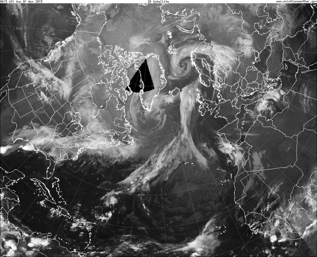
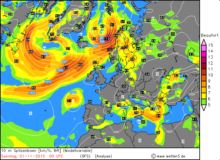
2015.11.01. – ESC: Two severe storms, warnings for N Europe

There are currently two storms in the MILK ESC warning area. One of them is currently located to the south of Greenland. MILK ESC calculated gusts of over 116km/h in this storm. It will move towards the east and affect everything from Iceland to the British Isles within 24h. The second, by far stronger, storm is located in the far N of Norway. Severe storm warnings have been issued for Norway and Sweden. See below for more information!

2015.11.01 2015.11.01 2015.11.01 Pressure 2015.11.01 Sat 2015.11.01 - Wind Analysis

2015.10.28 – Wettervorhersage / Weather Forecast: BERLIN

Mittwoch, 28.10. – Es ist weitestgehend heiter, ab und zu kann es aber auch ein paar mehr Wolken am Himmel geben. Trocken bleibt es aber auf jeden fall. Die Temperaturen werden von 5 auf maximal 12°C ansteigen, dazu ist leichter Wind aus Osten zu erwarten.

ZUSAMMENFASSUNG: Heiter bei 5 bis 12°C und leichtem Wind.


Donnerstag, 29.10. – Auch am Donnerstag wird es meist heiter sein, allerdings wird es auch viele hohe, dünne Eiswolken geben. Es bleibt aber weiterhin trocken. Die Temperaturen werden in der Nacht auf 5°C fallen, tagsüber aber bis zu 13°C erreichen. Der Wind wird leicht sein und im Laufe des Tages aus unterschiedlichen Richtungen kommen.

ZUSAMMENFASSUNG: Heiter bei 5 bis 13°C und leichtem Wind.


Freitag, 30.10. – Am Freitag wird es größtenteils sonnig sein, es kann aber weiterhin dünne und hohe Eiswolken geben, aus denen aber kein Niederschlag fallen kann. Weil der Himmel klar ist, wird es in der Nacht bis zu 3°C kalt, tagsüber kann es aber 14 oder sogar 15°C warm werden. Dazu ist ein leichter Wind aus südöstlichen Richtungen zu erwarten.

ZUSAMMENFASSUNG: Sonnig bei 3 bis 15°C und leichtem Wind


WEITERE AUSSICHTEN:


Samstag, 31.10. – Heiter, 6 bis 16°C

Sonntag, 01.11. – Sonnig, 6 bis 15°C

Montag, 02.11. – Sonnig, 2 bis 13°C

Dienstag, 03.11. – Wolkig, 1 bis 11°C

Mittwoch, 04.11. – Heiter, 0 bis 11°C

Donnerstag, 05.11. – Sonnig, 0 bis 10°C

Freitag, 06.11. – Sonnig, -1 bis 11°C


———————————————————————————–


Wednesday, 28.10. – Fair at 5 to 12°C and light wind.


Thursday, 29.10. – Fair at 5 to 13°C and light wind.


Friday, 30.10. – Sunny at 3 to 15°C and light wind.


TREND:


Saturday, 31.10. – Fair, 6 to 16°C

Sunday, 01.11. – Sunny, 6 to 15°C

Monday, 02.11. – Sunny, 2 to 13°C

Tuesday, 03.11. – Cloudy, 1 to 11°C

Wednesday, 04.11. – Fair, 0 to 11°C

Thursday, 05.11. – Sunny, 0 to 10°C

Friday, 06.11. – Sunny, -1 to 11°C

2015.10.27 – ESC: Storm WYMAR and a new storm

Currently ESC is monitoring two storms. Storm WYMAR continues to exist off the W coast of the British Isles, while a new storm has appeared just off the coast of Canada, visible in the GFS peak gust analysis map. Below are the current GFS peak gust analysis, and the satellite image by the DWD.

2015.10.27 Sat 2015.10.27 Wind analysis

2015.10.27 – Wettervorhersage / Weather Forecast: BERLIN

Dienstag, 27.10. – Es ist meist sonnig, mit einigen hohen, dünnen Wolken. Dabei bleibt es trocken. Die Temperaturen werden zwischen 4°C in der Früh und 14°C am Nachmittag liegen, dabei ist ein meist leichter Wind aus südöstlichen Richtungen zu erwarten. Am Abend kann es Böen um 40km/h geben.

ZUSAMMENFASSUNG: Meist sonnig mit hohen Eiswolken bei 4 bis 14°C und leichtem Wind.


Mittwoch, 28.10. – Wie schon am Dienstag, wird es auch am Mittwoch meist sonnig sein, wieder wird es hohe und dünne Eiswolken geben. Die Temperaturen werden von 5 bis 13°C reichen. Der Wind wird meist leicht sein und aus Südosten bis Osten kommen. In der Früh kann es Böen um 40km/h geben.

ZUSAMMENFASSUNG: Meist sonnig mit hohen Eiswolken bei 5 bis 13°C und meist leichtem Wind.


Donnerstag, 29.10. – Am Donnerstag wird es die meiste Zeit heiter sein, also ist nochmals Sonne zu erwarten. Die Temperaturen werden von 4 bis 16°C reichen. Der leichte Wind wird im Laufe des Tages aus unterschiedlichen Richtungen kommen.

ZUSAMMENFASSUNG: Heiter bei 4 bis 15°C und leichtem Wind.


WEITERE AUSSICHTEN:


Freitag, 30.10. – Heiter, 5 bis 15°C

Samstag, 31.10. – Sonnig, 6 bis 16°C

Sonntag, 01.11. – Sonnig, 6 bis 15°C

Montag, 02.11. – Sonnig, 5 bis 15°C

Dienstag, 03.11. – Sonnig, 5 bis 15°C

Mittwoch, 04.11. – Heiter, 4 bis 13°C

Donnerstag, 05.11. – Heiter, 4 bis 13°C


—————————————————————————


Tuesday, 27.10. – Mainly sunny with high and thin ice clouds at 4 to 14°C and light wind


Wednesday, 28.10. – Mainly sunny with high ice clouds at 5 to 13°C and mostly lightly wind


Thursday, 29.10. – Fair at 4 to 15°C and light wind


TREND:


Friday, 30.10. – Fair, 5 to 15°C

Saturday, 31.10. – Sunny, 6 to 16°C

Sunday, 01.11. – Sunny, 6 to 15°C

Monday, 02.11. – Sunny, 5 to 15°C

Tuesday, 03.11. – Sunny, 5 to 15°C

Wednesday, 04.11. – Fair, 4 to 13°C

Thursday, 05.11. – Fair, 4 to 13°C

2015.10.25 – ESC: Severe Storm WYMAR to make Landfall in British Islands

The severe storm WYMAR is predicted to make landfall in the British Isles within 24 hours. Peak gusts in the storm currently are calculated to be near 150km/h, the central pressure currently is 979hPa. Below are the warnings that were issued. Red: Storm warning (within 24h) Yellow: Storm watch (within 48h).

The storm can be seen clearly in the satellite images as well.

2015.10.25 Warn

2015.10.25 Sat 2015.10.25 Analysis 2015.10.25 Gusts

2015.10.24 – Warnings for Europe at 05:45UTC

  • Austria: No warnings
  • Bosnia and Herzegowinaa: No Warnings
  • Belgium/: No Warnings
  • Bulgaria: No Warnings
  • Switzerland: No Warnings
  • Cyprus: No Warnings
  • Czech Republick: No Warnings
  • Germany: No Warnings
  • Denmark: No Warnings
  • Estonia: No Warnings
  • Spain: Strong Rain (Canarias)
  • Finland: Rough seas (All coastal areas)
  • France: No Warnings
  • Greece: Storm (Attiki, E Sterrea & Evvoia, Kyklades, NE Aegean Islands), Strong Thunderstorms (Dodecanese Islands, Kriti, Kyklades, NE Aegean Islands), High Wind (Attiki, E Sterrea & Evvoia, Kyklades, NE Aegean Islands, Thraki), Strong Rain (Attiki, E Sterrea & Evvoia, Kyklades, NE Aegean Islands, Thessalia)
  • Croatia: Fog (Gospic Regija, Karlovac Regija, Osijek Regija, Zagreb Regija)
  • Hungary: Fog (Central Hungary, Northern Great Plain, Northern Hungary, Southern Great Plain)
  • Ireland: Strong Rain (Connacht)
  • Iceland: No Warnings
  • Italy: High Wind (Basilicata, Puglia)
  • Luxembourg: No Warnings
  • Latvia: No Warnings
  • Montenegro: High Wind (Entire nation)
  • Macedeonia: High Wind (North-Vardar, South-Vardar)
  • Malta: No Warnings
  • Netherlands: Offshore High Wind (Rottum, Texel)
  • Norway: High Wind (Hordaland, Sogn og Fjordane)
  • Poland: No Warnings
  • Portugal: No Warnings
  • Romania: No Warnings
  • Serbia: Fog (Entire nation)
  • Sweden: Rough Seas (Bay of Bothnia, North Sea of Bothnia, Skagerrak, South Sea of Bothnia, The Quark, Vänern
  • Slovenia: No Warnings
  • Slovakia: No Warnings
  • UK: No Warnings

2015.10.24 – ESC: Wind analysis for Europe

We currently have a storm low pressure system in the far N of Europe, currently affecting mainly Iceland and the coast of Norway. However, out on the open Atlantic a new, currently still weak, low pressure area has showed up – this is predicted to turn into a severe storm within 24h. We will keep you updated.

2015.10.24 Gust analysis

2015.10.23. – Storm VALENTIN, showers in E Greece

Currently there is only one storm system in the European / N Atlantic region, named storm VALENTIN. However, there are still thunderstorms and strong showers caused by a low over Greece. Locally, there can be storm gusts again there.

Storm VALENTIN is currently affecting mainly Iceland and the Faroe Islands. See the Wind Analysis for further details about the region affected.

2015.10.23 pressure analysis 2015.10.23 Wind analysis