

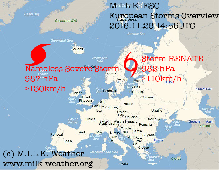
This is the ESC European windstorm overview, issued on the 26th of November, 2016 at 15:00UTC
There are currently two storm systems in the region.
Storm RENATE has moved to the east and is now located over the baltic with a central pressure of 982hPa and peak gusts still exceeding 110km/h. In the next 24 hours, RENATE will be mainly affecting Norway and Sweden as well as the Baltic Islands, but storm gusts may also occur at the baltic coasts of the Finland, the Baltic countries , Kaliningrad and parts of Poland. Norway and Sweden are expected to move out of the storm field within the next 24 hours, however the Baltic will continue to experience storm gusts over 100km/h, hence a storm watch has been issued for the baltic coast also in the regions of a storm warning.
The nameless severe storm located over the northern Atlantic is predicted to further intensify and move further towards the north. Towards the end of the 48-hour watch period, the edge of the system’s storm field will reach Iceland, hence a storm watch has been issued (due to the timeframe and also uncertainties in intensity and exact location).
This is the ESC European windstorm outlook, issued on the 26th of November, 2016 at 15:00UTC
For current storm systems up to +48h, please refer to the ESC European windstorm overview.
The rest of MONDAY will be fairly calm, with the only significant wind field being an area of gusts up to 95km/h over the North Sea that may possibly also affect the coast of Iceland and other North Sea islands.
On TUESDAY, a storm system is expected to form off the coast of Norway, with peak gusts especially at the coast and on mountains. Gusts are expected to exceed 115km/h. At the same time, a second storm will be forming to the southeast of Greenland; by the end of Tuesday it is forecast to pack gusts of over 125km/h.
Generally windy conditions will continue to persist over the Baltic, as in the previous days, especially for the first half of WEDNESDAY. The storm field from the northern Atlantic will move across the north of the UK and into the North Sea. Other than the UK, Norway, Germany, Denmark and the Netherlands should expect gusts over 105km/h.
On THURSDAY, this storm will continue to advance into eastern Europe and may well reach as far south as Hungary with gusts over 110km/h.
FRIDAY will see Thursday’s storm gradually dissipate over far eastern Europe over the course of the day, as generally stormy conditions persist over the northern Atlantic.
On SATURDAY, a storm packing over 135km/h winds and located near the coast of Greenland is expected to move eastwards and affect especially Iceland, and to a lesser extent the North Sea islands and possibly the far north of the UK and Ireland.
Below are the ESC overview, as well as the warnings and watches map.
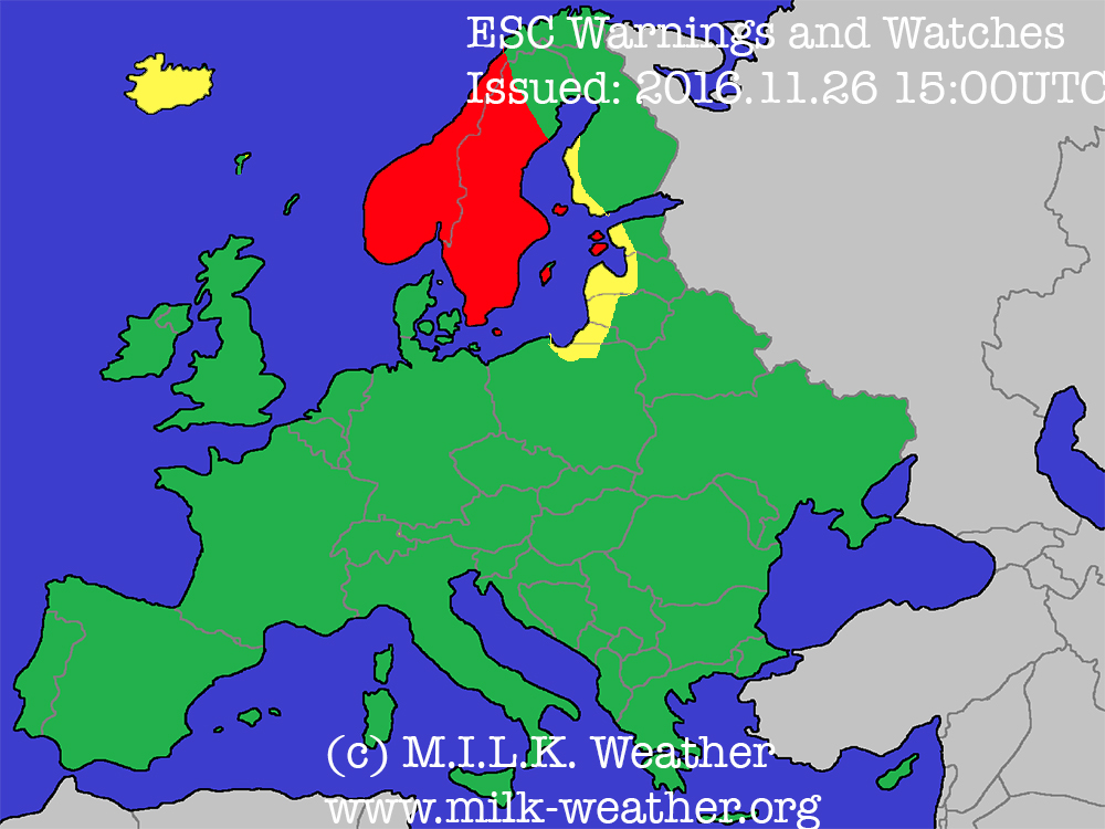
Red: Storm warning (>70km/h likely within 24h)
Yellow: Storm watch (>70km/h possible within 48h)