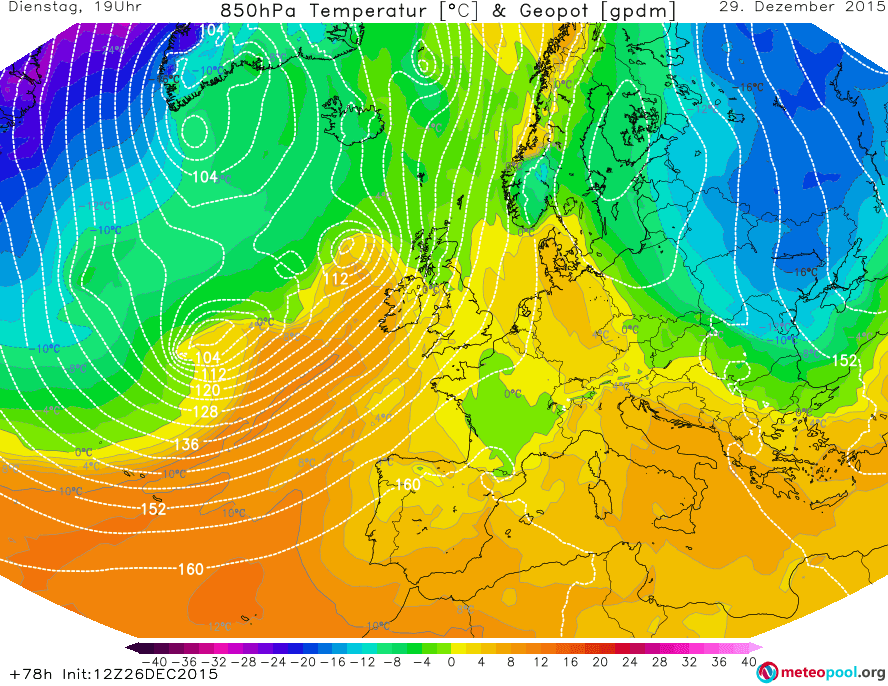
Even though there are still big differences between the ways that the forecast models predict the situation, most of them do say that the temperatures in Europe will drop, at least for a short time. We will look at ONLY THE GFS and UK Met Office models in this forecast. Please note that GFS (and UK Met Office) isn’t always correct and other forecast models may be better.
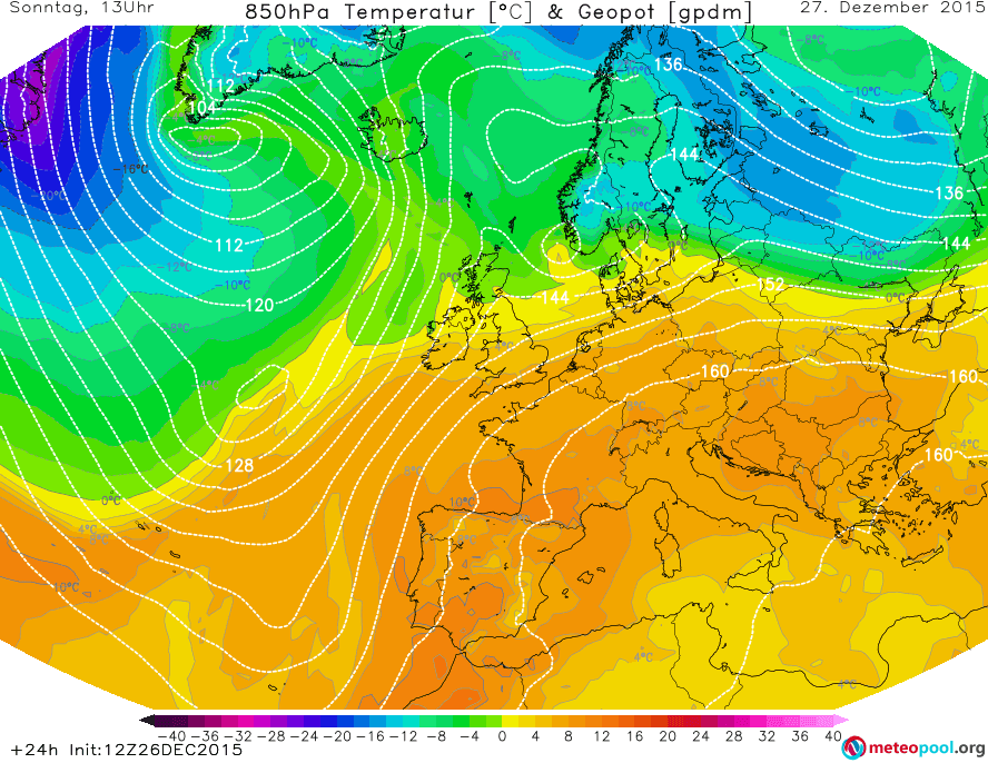
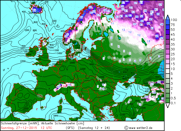
Tomorrow the overall situation will stay very similar to today. There will be a cold air mass over scandinavia, which will advance towards the southeast, into russia. Other than that, it will stay fairly mild even though to the north of the chain of low pressure areas and their associated fronts it will be a little cooler. At the back of a powerful low near Greenland, cold air will be advected towards the southeast, however it will not affect Europe. The minimum temperatures will stay above zero in most of Europe except Scandinavia, Russia and the mountains. A snow cover will continue to exist in much of Scandinavia and Russia as well as the highest peaks of the Alps and in the Scottish highlands.

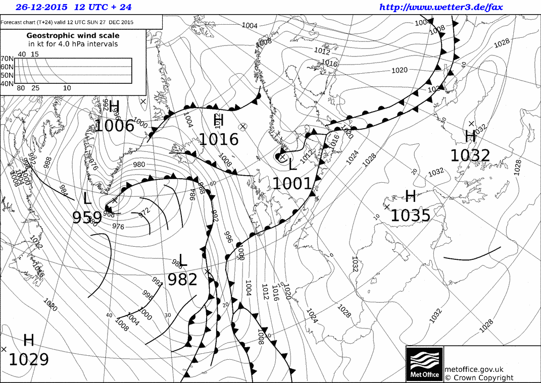
The weather over most parts of Europe will remain warm also on Monday. The powerful low pressure area near Greenland will continue to deepen and reach a central pressure of 951hPa on Monday, 12UTC. It’s frontal systems will span all the way from Greenland/Iceland over the British Isles and the Iberian peninsula. Below is the UK Met Office’s prediction of the SSL pressure and location of the fronts.

In front of the low pressure area and with the help of the high (1033hPa) located over Italy, warm air will be advected from the south and/or southwest up to Iceland and possibly even Greenland. Cool air continues to linger of Russia and especially northeastern Scandinavia, and will slowly start advancing towards the South or southsouthwest. Below is the 850hPa temperature and geopotential height map by GFS for Monday, 12UTC.

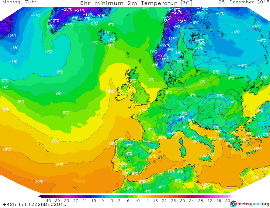
The minimum temperatures will, again, be mainly above zero, except for the mountains, Scandinavia, Russia and the Baltic states.
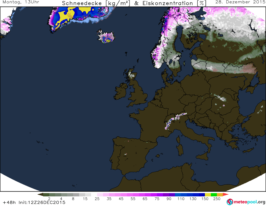
Snow will be on the groundin Scandinavia and Russia as well as along the front that the cold air mass, advecting to the southwest, causes. Other than that, snow is only found on the highest peaks of the Alps, southeast Euope and the Scottish highlands.
On Tuesday, the high pressure area located over northeastern Scandinavia will further strenghten, and at 12UTC a central pressure of 1047hPa is forecast by the UK Met Office. The frontal system, in front of which a large warm air mass was advected towards the north on Monday, will weaken and the flow of warm air will do so to. Behind the front(s), a cooler air mass will move in, however a general southwesterly flow will continue to exist, thanks to new low pressure areas moving towards Europe over the Atlantic. The front caused by the cold air coming from Scandinavia/Russia will continue to move towards the SW (or so). UK Met Office predicts it to be located as far west as eastern Germany, while GFS predicts the cold air mass to still be quite a bit further east.
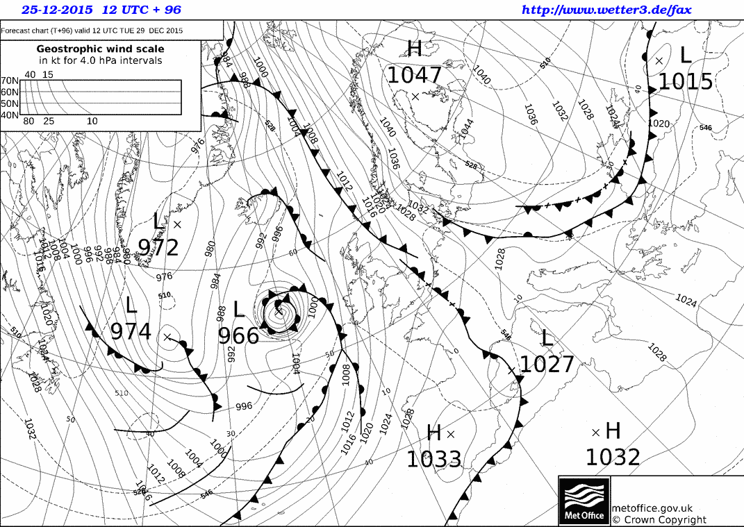
Warm air will continue to dominate in western Europe, and even warmer air masses will be advected by the low(s) over the Atlantic. The cold air over eastern Europe will continue to spread to the south and southwest, and at the leading edge of teh advance there will be a cold front (see the map above). GFS does not calculate the cold air mass to reach Germany yet, as the UK Met Office does.
While the minimum temperatures over western Europe will still stay largely the same, those over eastern Europe will, in many places, be lower than the days before.

The cold front at the leading edge of the cold air mass coming from Russia is not expected to produce a lot of precipitation anymore on Tuesday, and especially not snow that would stay on the ground. The areas in which snow will be covering the ground will stay largely the same as on Monday.
On Wednesday, the differences between the predictions by the GFS and the UK Met Office will be even bigger than they were on Tuesday. UK Met Office predicts a very impressive low over Iceland, with a 12UTC central pressure of only 939hPa. In front of the frontal system of this low-pressure area, warm air will be advected from the south, over far western Europe and the British isles and into Scandinavia, while just to the east, over most of Europe, the cold Scandinavian/Russian air mass will dominate, with the leading fronts of the BeNeLux states and Germany, along the coast of the Balkans, to the north of Greece and along the black sea. According to the UK Met Office, everything to the east of Germany will be affected by the cold air mass from the northeast.
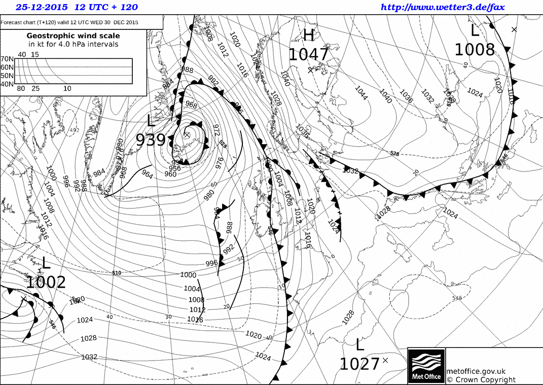
GFS, on the other hand, also predicts the advection of warm air far to the north in front of a low somewhere around Iceland. However, in GFS, the cold air mass from the east will still reamain further in the east and mainly spread to the south and southwest, not so much to the west. Most of central Europe will still largely be affected by a warm air mass.

Nonetheless, the temperatures over central Europe will be lower than on the previous days, and the minimum temperatures will, in many places, drop below 0°C. The temperatures in eastern Europe will continue to decrease compared to the previous days.
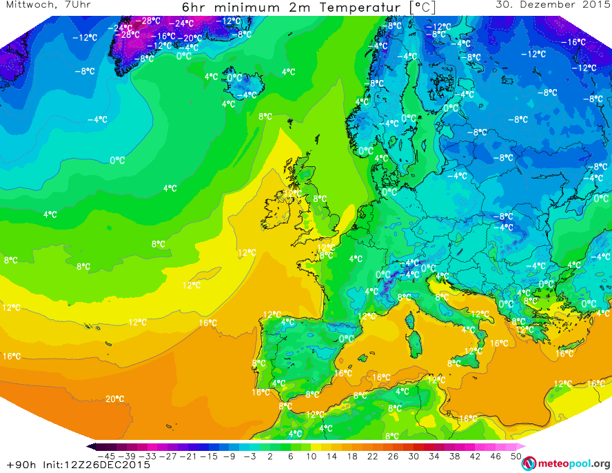
The snow will stay largely where it was in the previous days, but a little bit of new snow can fall in the mountains of Romania.
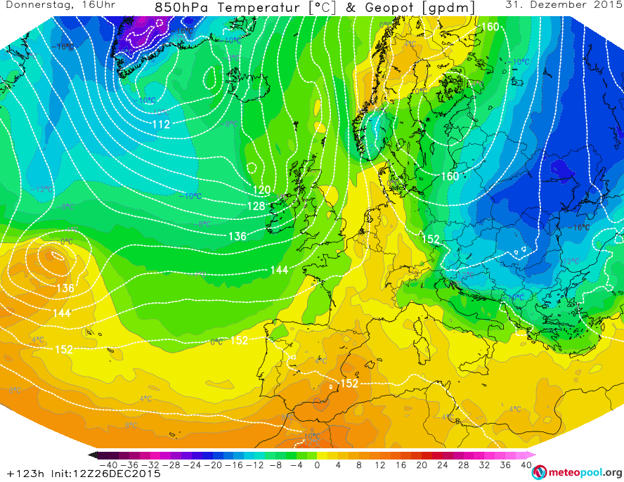
For Thursday, GFS expects the cold air mass to move further to the southwest, all the way to the Adriatic sea. At the same time, a cooler air mass will move towards the UK and Ireland from the northwest. Meanwhile in northern Scandinavia, “warm” air will take over.
PART TWO WILL FOLLOW!


